
Elevation 322 m | Prominence 158 m | |
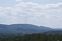 | ||
Shinall Mountain, elevation 1,056 ft (322 m), is located near the Chenal Valley neighborhood of Little Rock, Arkansas, in the foothills of the Ouachita Mountains. It is the highest point in Pulaski County.
Map of Shinall Mountain, Big Rock Township, AR 72223, USA
Because the neighborhood (and Chenal Parkway, a major West Little Rock thoroughfare named for it) have similar-sounding names, the mountain is often misspelled "Chenal Mountain"; but "Chenal" is a French language word chosen by Chenal Valley's developers for foreign branding because of its similarity to the mountain's name. The mountain was known as "Shinall" long before either the neighborhood or the parkway existed. However, a book by noted Little Rock author, Fred W. Allsop published in 1931 by the Grolier Society, entitled, Folklore of Romantic Arkansas Vol. 1, page 90 states, "Shinall Mountain is a phonetically-spelled corruption of the French name Chenault, a family which in early days settled near its base. Its location is near the Joe T. Robinson Schoolhouse, in Pulaski county, and is reached via Perryville road and the 12th Street Pike in Little Rock; about 14 miles west of Forest Park." The Chenault families were those of Elijah Nelson Chenault and Benjamin Franklin Chenault who settled there before the Civil War on the southwest base of what became Chenault Mountain.
Although Pinnacle Mountain, in Pinnacle Mountain State Park to the north, is more prominent because it is located near the Arkansas River (even the USGS quad map for the Shinall Mountain area is called "Pinnacle Mountain"), it is only 1,011 feet (308 m), slightly shorter than Shinall Mountain.
Other than the Chenal Valley neighborhood, Shinall Mountain is best known for the numerous broadcast towers built atop it. The transmitters of television stations KARK-TV, KARZ-TV, KKAP, KLRT-TV, and KTHV, as well as the KLRA-CD repeater of KMYA-DT and numerous radio stations, are located there. The KARK/KTHV was built in 1954 and KARK-FM (now KABZ) was added in 1967. In 1972, KLAZ now KURB became the first stand-alone FM station on Shinall. In 1984, KLRT became the first stand-alone TV station on Shinall Mountain. Shinall is also the transmitter location of NOAA Weather Radio All Hazards station WXJ55, which is programmed by the National Weather Service Forecast Office over in North Little Rock. The station covers the Little Rock Metro area and the rest of Central Arkansas.
After the 2008 collapse of its former tower near Redfield, KATV started broadcasting from Shinall Mountain using KTHV's backup analog transmitter and a digital subchannel of KWBF; it received Federal Communications Commission (FCC) approval to relocate its tower there permanently [1] and now broadcasts from Shinall Mountain. With the relocation of KATV, the Little Rock affiliates of the "big four" networks (ABC, CBS, Fox and NBC), as well as MyNetworkTV, RTN and Daystar, all broadcast from Shinall Mountain.