
Country Japan Population 97,540 (Dec 2016) | Phone number 0547-37-8200 Local time Saturday 10:56 PM | |
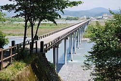 | ||
Weather 7°C, Wind N at 11 km/h, 89% Humidity Points of interest Hōrai Bridge, Shimadahorai Hot Spring, Ōi Shrine, Makinohara Park, Tashironogoonsen Itawari Hot Spring | ||
Shimada (島田市, Shimada-shi) is a city located in Shizuoka Prefecture, Japan.
Contents
- Map of Shimada Shizuoka Prefecture Japan
- Geography
- Surrounding municipalities
- History
- Economy
- Education
- Railway
- Highway
- International relations
- Local attractions
- Notable people from Shimada
- References
Map of Shimada, Shizuoka Prefecture, Japan
The city, which covers an area of 315.7 square kilometres (121.9 sq mi), had an estimated population in December 2016 of 97,540, giving a population density of 309 persons per km2.
Geography
Shimada is located in the Shida Plains of west-central Shizuoka Prefecture. It is located on both banks of the Ōi River. The area enjoys a warm maritime climate with hot, humid summers and mild, cool winters.
Surrounding municipalities
Shizuoka Prefecture
History
Shimada (Kanaya) began as an outlying fortification to Kakegawa Castle erected by Yamauchi Kazutoyo in the Sengoku period to control the crossing of the Ōi River. In the Edo period, Kanaya-juku and Shimada-juku developed as post towns on the Tōkaidō highway connecting Edo with Kyoto. The area was mostly tenryō territory under direct control of the Tokugawa shogunate with a daikansho based at a Jinya located within Shimada-juku. As the Tokugawa shogunate forbade the construction of any bridge or establishment of a ferry service on the Ōi River for defensive purposes, travellers were often detained at either Shimada or Kanaya for days, sometimes weeks, waiting for the river levels to fall to fordable levels. The first bridge (the Hōrai Bridge) across the river connected these two towns in 1879, after the Meiji Restoration.
During the cadastral reform of the early Meiji period in 1889, Kanaya Town was created within Haibara District, and Shimada Town within Shida District. On April 16, 1889, the two towns were connected by rail, with the opening of Shimada Station on the Tōkaidō Main Line.
Shimada was elevated to city status on January 1, 1948. On January 1, 1955, it annexed neighboring Rokugo Village, Otsu Village, Daichō Village and a portion of Ikumi Village. On June 1, 1961 it further expanded through annexation of Hatsukura Village.
On May 1, 2005, the town of Kanaya (from Haibara District) was merged into Shimada.
On April 1, 2008, the town of Kawane (also from Haibara District) was also merged into Shimada.
On March 15, 2012, the city became the second municipality, after Tokyo, outside Tōhoku to accept debris from the 2011 Tōhoku earthquake and tsunami for disposal in the town's incinerators. Other cities had been reluctant to accept debris from the disaster, in spite of being asked to help recovery efforts, because of fears that the debris were contaminated by radiation from the Fukushima Daiichi nuclear disaster.
Economy
The economy of Shimada is primarily agricultural, with green tea as the main crop. Light industries of Shimada include factories for the production of automobile components.
Education
Shimada has 18 elementary schools, nine middle schools and five high schools, as well as one special education school.
Railway
Owada • Ieyama • Nukuri • Kawaneonsen-Sasamado
Highway
International relations
Shimada is twinned with the following cities.