
Prominence 400 m | ||
 | ||
Similar Mulkila, Chau Chau Kang Nilda, Reo Purgyil, Manirang, Jorkanden | ||
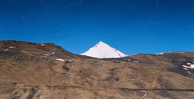
Shilla is a mountain peak close to Spiti Valley, part of the Himalaya mountains. Its peak is 6,132 metres (20,118 ft) above sea level. It is in Himachal Pradesh in Northern India.
Contents
Map of Shilla, Dhar Dum Bachen, Himachal Pradesh 172114
This rarely seen Shilla peak on the divide between Lingti and Shilla Nullah/nala became so famous that any mention of Spiti led to the memory of it and vice versa as Shilla held a dubious altitude record for 47 years in the trans-Himalayan region of Himachal Pradesh in India.
Nomenclature: Shilla: Shi = death. Shi-la = range or peak death. Other meanings locally offered were 'a place of monastery' or 'a gateway to heaven’.
Legend of Shilla
It was first reported to have been climbed in 1860 by an unnamed khalasi of the Survey of India, who erected a pole on the top. This was reported in 'The Synoptical Volume XXXV of the Trigonometrical Survey of India' published in 1910. It referred to it as peak 'Parang la No. 2' and later the name was changed to Shilla in the Survey Office. The peak appears as 'Parang la No. 2 S' with height of 23,064 ft on SOI Sheet 64 SW, published August 1874 (Gyah is mentioned as GUA Snowy Peak, 22,309 ft on the same sheet). Thus Shilla remained a dubious altitude record for 47 years till Dr Longstaff climbed Trisul 23,360 ft in 1907.
First visitors to Spiti had doubts about its" height. In 1952 Snelson and de Graaff felt that it was a much smaller peak and a high peak was observed to its NE. Holmes and Braham felt the same. A letter in H.J. Vol. XXVI, p. 169 established its height at 20,050 ft. Now on the latest maps with modern methods of survey the height of Shilla is firmly established as 6132 m (20,120 ft) and Gyah as 6794 m (22,291 ft). Thus Shilla has lost 2944 ft while Gyah lost only 18 ft! One wonders where the SOI went wrong.
The Indian expedition which climbed Shilla in 1966 did not find any survey pole (but who expects it there after 106 years!) and they questioned why the climb done in 1860 was reported after 50 years (1910) by the Synoptical Volume. Did the khalasi climb it or is it a legend?
In Spiti it is found that more than any other peak Shilla is the most known point to the locals. Almost every lama and villager seems to know of it, however far away. They associate it with a place for the dead leading to heaven and still believe that it is the highest point in Spiti and Ladakh from which one can see heaven It has a legendary air built around it. No one, the most elderly lama included, seems to be aware of the ascent by a khalasi, to confirm or deny it. And very few villagers in Langja knew about the route to it. Anyway according to them it is still the highest and virgin. The Shilla legend is here to stay.