The organizers of the SVRR planned to construct a railroad from the Pennsylvania Railroad (PRR) station in Hagerstown, Maryland (a branch out of Harrisburg, PA called the Cumberland Valley Railroad) to the Virginia and Tennessee Railroad (V&T) in Salem, Virginia. The route called for 243 miles (391 km) of new construction. The line follows closely the great iron ore belt along the western slope of the Blue Ridge Mountains.
Peter Bouck Borst of Page County, Virginia introduced a charter for the railroad for a bill before the Virginia General Assembly in 1866. The ambitious plan was to build a railroad from Harpers Ferry, West Virginia, to the Virginia Central Railroad somewhere near Staunton, to a connection with the V&T around Salem, and finally to somewhere near the southwest corner of Virginia to meet the East Tennessee and Virginia Railroad at Bristol, Virginia.
Since the route traversed three states (Maryland, West Virginia, and Virginia) three legislative authorizations were required. Virginia provided approval on February 23, 1867. West Virginia approved the construction idea on February 25, 1870. Maryland provided the final approval needed on April 4, 1870.
On March 14, 1870, the company was formed and the first president, Peter Bouck Borst, was elected.
After Maryland approved construction of a bridge over the Potomac river anywhere between Harpers Ferry and Williamsport, the Pennsylvania Railroad (PRR) took notice. There could be link with rival B&O railroad, as well as a link with its own Cumberland Valley Railroad, just north of Williamsport in Hagerstown. This new north/south line would be the key to capturing the traffic on numerous just-acquired southern lines and directing it to the port of Philadelphia. The competing B&O wanted to divert the riches of the area to the port of Baltimore and expand into the south. Each tried to cut off the other from the south. Meanwhile, Virginia really didn’t want either to succeed so that traffic would be directed to the Norfolk port.
The PRR began purchasing stock in the SVRR, and took effective control of it. B&O took control of a competing north/south line called the Valley Railroad. The plans showed the railroads were to run parallel to each other through the valley, sometimes just a few miles apart. The race was on.
Main line construction (1870–1882)
The Central Improvement Company (a subsidiary of Pennsylvania Railroad) was awarded a contract to construct 224 miles (360 km) of the SVRR from Shepherdstown to Salem for $35,000 a mile. The work was to be completed by August 1872. The major source of capital came from the sale of 6% mortgage bonds backed by the Pennsylvania Railroad.
In 1871, Thomas A. Scott was elected as the second president of SVRR; he was also a Vice President of the Pennsylvania Railroad. Peter B. Borst was forced out because of his involvement with a competing plan for a similar rail line called the Luray Valley Railroad Company that was pushed through the Virginia General Assembly in 1870.
In August 1871, the Central Improvement Company submitted a proposal to cancel the construction contract, asking for payment only for work completed. The proposal was rejected by SVRR. In 1872, the deadline for completion of the railroad was extended to January 1875 and 94 miles (151 km) of work south of the C&O railroad in Staunton eliminated. Service began between Shepherdstown, WV and the Shenandoah River on December 15, 1879.
In September 1872, the Cumberland Valley Railroad (a subsidiary of Pennsylvania Railroad) was asked to construct the tracks from their station in Hagerstown, MD to Shepherdstown, WV. Service began on that stretch in 1880.
Problems with PRR escalated over the inability to obtain a traffic contract with the Cumberland Valley Railroad. SVRR sent a team of surveyors during the summer of 1880 into Pennsylvania indicating a desire to build a line to Harrisburg to connect with the competing Philadelphia and Reading Railroad line. The bluff worked and a contract was worked out. But the split with PRR was now inevitable.
Also in 1880, service began on the section south of the Shenandoah River between Elkton and Waynesboro. In 1881 the north and south sections were connected. Finally, in 1882, it stretched south to meet the Norfolk and Western Railroad in the new railroad town of Roanoke, Virginia. The track was now complete.
Meanwhile, rival Valley Railroad (VRR) was trying to raise capital. With Robert E. Lee as its spokesman, it convinced Baltimore to authorize $1,000,000 to secure funding by other Virginia counties. Baltimore was to gain considerably by having the traffic from the richest parts of the south directed its way. Many delays occurred, particularly after the recession on the 1870s, but traffic finally began between Harrisonburg and Staunton in 1883. The southern section was never constructed.
Recession, strikes and bankruptcy (1882–1890)
The financial panic of 1873 brought a deep recession that suppressed business into the 1880s. In 1882 SVRR received a loan of $79,000 from Philadelphia financiers E.W. Clark & Co. to cover that year’s shortfall. The life of all the bridges was ending and significant funds would be needed in the coming years.
In 1882, N&W made a deal with PRR to swap the SVRR share capital for N&W common stock. SVRR got a loan from N&W of $600,000, plus up to $200,000 per year for 3 years. PRR kicked in $150,000 as advanced payment for highly discounted future traffic contracts. Control of SVRR stock was now with N&W. In 1883, SVRR floated $1.8 million of income bonds. Revenues continued to be far below forecast due to the bad economy.
In early 1885, SVRR defaulted on its loan interest, taxes, payrolls, and bills. A Roanoke judge put the line in a receivership, but in December, the mortgage company holding its notes filed suit for liquidation of the road’s assets. The Norfolk and Western Railroad fought a legal battle for the next four years to regain control. On September 30, 1890, the SVRR was reorganized as the Shenandoah Valley “Railway”, with stockholders approval to sell to N&W. On December 2, the Shenandoah Valley Railway acquired the rights to the franchise of the Washington and Western Railroad. On December 15, 1890, N&W purchased the company outright for $6,000,000 of stock and added the rails to its system.
The competing Valley Railroad ran out of capital to build in 1884 and struggled until it went into receivership in 1896. The final length of that line was 36 miles (58 km) from Staunton to Lexington, the southern 51 miles (82 km) to Salem never finished. The line was never profitable.
Stations and other railroad locations
The names listed are for the station or siding, not necessarily the name of the town they were near or in. Many times the station names were changed because they were the same as another station on another line, which after the lines were connected became very confusing to customers. Towns that grew up around stations often chose the station name as their name.
Tracks were moved over time to eliminate steep grades and sharp curves, so the mile post values changed slightly throughout history. The mileage values listed are from the SVRR era, mostly the late 1880s. Most of these markers still exist along the tracks today, each showing H and a number to designate the mileage from Hagerstown.
The first date in parentheses is when the location first appeared in literature, whether there was station or not. A second date is the date the location/stop was eliminated (if known). A most definitive source of these dates are the annual reports, as they contain station/siding listings. Most stations were demolished in the 1950s, a listing of these has not yet been located.
Hagerstown, MD – mile post 0.0 (opened 8/19/1880): There was a junction in Hagerstown with the Pennsylvania Railroad System via the Cumberland Valley Railroad. There was also a junction with the B&O Railroad via the Western Maryland Railroad. It is unclear which stations, if any, were owned by the SVRR since there were so many companies present.
Saint James, MD – mile post 5.9 (8/19/1880): A combination (passenger and freight) station. The water tank that used to reside here was moved to Loch Laird in 1883. As of 2005, the station is a private residence located ¼ mile east on Maryland Route 68. The village was called Lydia earlier.
Spielman’s Siding (pre-1883): In Washington County; location was/is around 39°32'13"N 77°45'51"W
Grimes, MD – mile post 9.0 (8/19/1880): In Washington County; location was around 39°31'16"N 77°46'17"W. It is unknown if there ever was a station here, or if it was just a stop.
Little Ramsburg Siding (pre-1889): This may have previously been called Mondel’s Siding
Antietam (originally Sharpsburg), MD – mile post 14.1 (8/19/1880): A combination station. Sharpsburg station was renamed Antietam station after a head-on slow-speed train collision between a passenger train and an excursion train was blamed on the confusion between the names Shepherdstown and Sharpsburg. Danial and Peter Ahl operated an iron works near town. At some point in time the station was rotated, with the bay window now facing the highway instead of the tracks As of 2005, the station still resides in Sharpsburg, and is undergoing restoration as the future home of the Hagerstown Model RR Museum.
Shepherdstown, WV – mile post 16.9 (1879): A combination station. In 1870, $8,000 of bond money was given to the railroad on the condition that railroad car shops and a train maintenance yard be built in Shepherdstown. At the time, there was intense competition with nearby Charles Town for the potential jobs. Some properties had to be condemned to make room for the workshop. Many townspeople felt they were not paid fairly compensated for their lands worth, and went to court to fight for a fair settlement. The shops and maintenance buildings were torn down just a few years later, the SVRR had the town's money and fulfilled the fine-print of the agreement.
The very first train to Shepherdstown arrived on January 1, 1879. However, that was just a construction train. Although lots of people were on hand to see the first train arrive, the town decided to mark the event with a little more fanfare a week later when passengers arrived. People from the SVRR, the contractors who built the track, and many other dignitaries were invited to attend. A parade made up of the Town Council, the local band and others started at Shepherd College (now McMurran Hall) and marched to the station to meet the train. It arrived at about 12:15 p.m. on January 8, 1879, to loud cheering, music from Criswell’s Cornet Band, and the ringing of every church bell in Shepherdstown.
The first train station (built before 1884) was a wooden structure, located south of Princess St. (behind the Southern States). It looked very much like the Antietam station at Sharpsburg. In Nov of 1884 the safe in the station was robbed of about $60 by professionals who drilled a hole into it and blew it up with powder. Some time later the current station was built exclusively for passengers, and the old station was used exclusively for freight. As of 2006, the passenger station has been restored and is accessible though it is being used commercially.
Morgan’s Grove Siding (1885): Siding extended 165 feet (50 m) in 1886. Extended 524 feet (160 m) in 1890. As of 2005, the siding still exists. A stone spring house, which remains on the Morgan Grove Park grounds located next to the siding, was the meeting point in 1775 of the men of Berkeley County for the famous Bee Line March to Concord.
Shenandoah Junction, WV – mile post 23.1 (1879): There was a junction here with the main line of the B&O Railroad. There was quite an operation here consisting of a passenger station, a freight station, a pump house and an engine coaling station. The stations have been torn down.
Aglionby's Siding (1879, gone 1889)
Charles Town, WV – mile post 28.4 (1879): There was a combination station, a freight house, and a signal tower here. There was a junction here with the Valley Branch of the B&O Railroad (hence the signal tower), a line that moved much of the construction materials needed to build the nearby section of the SVRR. The combination station shown at left was under restoration in 2005 and completed in 2006. It is situated near the NS right-of-way, but not in its original location.
Chew's Siding (1883): This is probably the private siding built in 1883 to Eagle Mfg Co. Research efforts have turned up the name Roger Preston Chew (1843–1921). He apparently was the president of Eagle Mfg Company. He was also a Confederate colonel who raised a battery of horse artillery, "Chew's Battery," which became part of the famous Laurel brigade under Jackson's command. He participated in all Jackson's campaigns until Jackson's death; and was promoted to chief of cavalry's guns serving through the Wilderness, Petersburg and Appomattox.
Wheatland, WV – mile post 32.5 (1879): Private station built in 1883. No town buildings seem to exist today, just a railroad crossing.
Rippon, WV – mile post 33.7 (1879): The original station burned on Oct 21, 1883, and was rebuilt. A new combination station was moved from Lofton in 1886. Cattle pen and 166 feet (51 m) of siding was built 1886. The town is located 6 miles (9.7 km) from Charlestown and ¾ mile from SVRR depot. In 1890 the town contained an Episcopal Church, several stores and shops. Another church, Presbyterian, was located about one mile (1.6 km) from the village, on Bullskin Run (a stream). Some documents misspell this place as Ripon.
Fairfield (now Gaylord), VA – mile post 36.2 (1879): It is unknown if there ever was a station here, or if it was just a stop. Was named Gaylord by 1890. The post office pictured is off Gaylord Lane, a short road running parallel the westward lanes of Route 340.
Berryville, VA – mile post 39.9 (1879): Separate passenger and freight stations.
Brigg's Siding (Private, 1885)
Boyce, VA – mile post 46.2 (1879): Combination station located at the crossing of the SVRR and Millwood Turnpike from Winchester. Additional 940 feet (290 m) of siding was added in 1885. The wooden station was replaced in 1913 with a 141-feet long by 26-feet wide stucco-on-clay-block masonry building. Land acquisition and construction were financed with $17,500 in private funds from undisclosed sources. The new station had central hot-water radiator heating, electric lights, and inside rest room facilities.
The railroad agency was discontinued around 1956. Shortly before station closure, the large waiting room was rented to the Post Office Department and became the town's post office. The building was sold and the land under it was leased by the N&W Railway. During the time that it was a post office, other portions of the station were used by a FISH charity and also for livestock feed storage.
After the Post Office was moved to a new location on West Main Street, the station was sold and renovated as a restaurant with few modifications to its interior. Subsequently, it was owned by the Winchester Chapter, National Railway Historical Society, then by Bridgehead Fine Woodworking. In 2003 it was purchased by the Railway Mail Service Library and is now the home of an archival post office and railroad collection. A portion of the small waiting room is occupied by Railway Station Press, a historical letter-press collection.
White Post, VA – mile post 49.2 (1879, dismantled 1950s): White Post obtained its unique title through the fact that Lord Fairfax erected here a post and painted it white, upon which were inscriptions informing the traveler the direction in which lay Greenway Court and the distance to that seat of colonial royalty. The old station on the north side of Rte 628 was dismantled in the 1950s and a smaller one erected on the south side of Rte 628.
Ashby, VA – mile post 53.2 (1879, gone 1946)
Wheelwright's Siding (pre 1883)
Cedarville, VA - mile post 56.4 (1879)
Limekiln Siding, VA (1879): A .31 mile branch to Carson's Lime Kiln. Mistakenly called Lime Kiln in 1883 SVRR annual report.
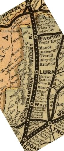
Riverton, VA – mile post 59.2 (1879, dismantled 1952): Nearby Front Royal refused to allow railroads in the town, so a combination station was built here on the northern bank of the Shenandoah river. The SVRR was a late comer to Riverton, so it bore the expense of building the tower "RV" controlling traffic at the junction with the Manassas Branch of the Virginia Midland RR. A new turn-table was built in 1890, along with 1,980 feet (600 m) of new siding.
In 1879, the three major businesses were the Riverton Flour Mills, Warren Manufacturing, and the Riverton Stone and Lime Company. The later was the first large traffic generator for the railroad, the reason why Riverton was the end of the first phase of the railroad. Today, the tracks appear to be under the bridge leading to Front Royal. The SVRR station was located somewhere north of the river.
Spoke Factory Siding (post 1885): Colbert Hessler was Vice President. Apparently the factory was located in Mount Gilead, Loudoun County, Virginia.
Front Royal, VA – mile post 62.1 (4/1/1880, dismantled 1952): The siding south of Front Royal was renamed Rando after the Randolph-Macon Academy, but the name never stuck. Hence it reverted to Front Royal(?). The combination station was dismantled in 1952, and a three-sided shelter was erected between Riverton and Front Royal on Kendrick Lane in Front Royal. More research needs to be done to disentangle the historical accounts of the different railroads in town.
Manor, VA – mile post 66.4 (5/10/1880): A three-sided shelter existed in 1910. No evidence of a full station has been found.
Purcell’s Siding (pre 1883, gone 1889)
Limeton (Limeton Siding up to 1890), VA (1886): Served the Limeton Lime Company plant at Karo Landing, VA. Combination station built in 1890.
Bentonville, VA – mile post 72.9 (5/10/1880): There was a combination station here. Bentonville was at a summit 751 feet (229 m) above sea level. The station received material from Superior Ochre, a paint ingredient manufacturer, and hides from the Mt. Vernon Tannery in nearby Browntown. On February 22, 1889, a boxcar somehow rolled down the track and was hit by a northbound passenger train, killing one.
Overall, VA – mile post 75.6 (9/6/1880): Originally this station was named Milford. Overall gets its name from the Overall family, large landowners at one time. One of the members of this family was Col. William C. Overall, who owned hundred of acres of land in that section. Today, there is a high trestle called Milford Bridge over where the town sign is on Route 340. Location and type of station unfound, but is probably on the northern side of the trestle since service stopped here while bridges were built to the south.
Dry Run Siding (pre 1883)
Rileyville, VA – mile post 79.8 (12/20/1880, gone 1952): The original station burned on Dec 19, 1883, and was rebuilt. A new combination station was built in 1890. The numerous Riley families soon became Rileyville. A nearby village called Cedar Point, doubtless due to a hill thickly clustered with cedar trees, dwindled after the station drove businesses to the top of the hill. There is a historical book of Rileyville at the Luray Copy Center.
Vaughn’s Summit, VA – mile post 83.0 (12/20/1880): Called Summit Siding originally, it was renamed Vaughn's Summit Siding after a nearby family, then renamed to Vaughn's Summit. Extended in 1883. Not sure if a station ever existed, though "siding" was dropped from its name which would imply so.
Kimball (now Elgin), VA – mile post 85.1 (12/20/1880, gone 1952): There was a combination station here. Kimball is named after F. J. Kimball, who at one time was president of the Norfolk and Western Railway. Name was changed to Elgin by 1890. The post office is still Kimball, though the railway station is Elgin, to prevent confusion with another railway station named Kimball in Southwest Virginia.
Luray, VA – mile post 88.8 (12/20/1880): There was both a passenger station and a freight station here. The caverns located near this station were (and still are) a major tourist destination, and a catalyst of much needed lucrative passenger traffic. Luray perhaps got its name from Lorraine in France, the similarity of the country around Luray and the French province being so striking. Others say that the town got its name from "Lou Ramey," an old blacksmith who is said to have lived and flourished in his day at this place, they contending that "Lou Ramey" finally dropped into "Luray".
Peter Bock Borst, involved heavily with SVRR, was the postwar development spokesperson for the Shenandoah Valley. With the motto, "It is better to wear out than rest out," the latter part of his life was filled with labor. On April 24, 1882, while in the service of legal matters at the Rust House, and in the presence of Judge Bird and several other lawyers, suddenly and noiselessly Borst fell back in his chair, and although a dozen hands were willing to go to his assistance he was dead from apoplexy, by the time they could lay him on the bed. Borst was laid to rest in Green Hill Cemetery. Isabella would survive her husband for several more years before passing in 1916 and being laid to rest next to Peter.
Spitler's Siding (1889)
Sands, VA (also Stanley, Marksville) – mile post 95.6 (12/20/1880, gone pre-1889): The combination station was located 1-mile (1.6 km) east of the town. In 1885, the station was known as Sands, being named after Joseph H. Sands, the superintendent of the SVRR. In 1890, the railroad was sold and the station name was changed to Stanleyton, which was later shortened to Stanley. James McNider was at the time President of the Stanley Furnace and Land Company. It was either his son or his nephew, Stanley McNider, after whom the Town was officially named in on 2/14/1890. The station was destroyed during a town-wide fire in 1909 (presumably a post-1890 station built by N&W).
Marksville, according to Page's veteran auctioneer George Bailey, got its name from a family by the name of Marks who long since lived at that place. All the family members are gone. It is unclear what was the relationship between Marksville and Stanley, though an 84-year-old lifelong resident of the area indicated that they were the same. A nearby bridge was called East Liberty, another name found on 1890 RR maps.
Beidler's Siding (private 1890): Research has not determined who/what Beidler was, but the siding still exists off Donovan Rd in Stanley, VA. As of 2006, a company called Masonite Door Corp has a manufacturing facility here. Interesting the name Donovan, see the entry for Ingham below.
Nauman's Siding (pre-1889): Named for the Nauman family that resided near this spot. The siding has not been located but may be at the other end of Donovan Rd as Beidler's Siding. The auto road, running parallel to the RR line, ends now about .6 miles south of Beidler's Siding.
Ingham (Siding pre-1889), VA – mile post 101.9 (12/20/1880): Combination station was built between 1885 and 1889. Presumably the station was near Ingham Rd which is a private road off Grove Hill River Rd. According to Google Maps, Ingham Rd used to cross the RR tracks. It then ran north, parallel to the tracks on the east side, ending above the Cold Springs Dr tunnel. There is a driveway running from Cold Springs Dr up toward the tracks. The pad may indeed lie there.
Grove Hill, VA – mile post 104.0 (12/20/1880?): The site is located off Rinaca Lane (RTE 610). The pad was not found, but the location was independently confirmed in 2006 by an 84-year-old Mr Comer who has spent his whole life off Crooked Run Rd, about a mile east off Grove Hill River Rd. Mile marker H104 is also visible to the south.
Milnes (now Shenandoah), VA – mile post 106.7 (12/20/1880): Both a passenger station and a freight station were located here. 50-ton iron-frame scale built in 1883. Cattle pen and 542 feet (165 m) of siding built in 1886. Coal wharf expanded and rebuild in 1889. The station still exists in quite good condition as an NS work building. As of 2006, it appears restoration is still onging as witnessed by bare framing inside. It is located off 1st street.
Named after William Milnes (1827–1889). He was born in England on December 8, 1827, and was eventually a Representative from Virginia. He immigrated to the United States in 1829 with his parents, who settled in Pottsville, Pa. He attended the public schools, learned the machinist’s trade, engaged in mining and shipping coal, then moved to Virginia in 1865 and settled in Shenandoah. There he engaged in the iron business, was a member of the State house of delegates in 1870 and 1871. Upon the readmission of Virginia to representation, he was elected as a Conservative to the Forty-first Congress and served from January 27, 1870, to March 3, 1871. After which he resumed the iron business, became president of the SVRR, and eventually died 08/14/1889 and buried in the family plot in Old Cemetery.
Through the work of William Milnes, Shenandoah became the midpoint between Roanoke, Virginia and Harrisburg, Pennsylvania and enabled town industries to ship out their goods through means other than the river. Milnes took advantage of the railroad's presence and erected the Big Gem Cast Iron Furnace. The Big Gem was completed in 1882 and produced 110 tons of iron ore per day. It became a popular tourist destination as well because of the sparks that could be viewed each night as red hot cinder was poured down the cinder bank.
On June 27, 1882, the name of the post office was changed from Shenandoah Iron Works to Milnes. On February 12, 1884, an Act was passed by Virginia General Assembly to incorporate the town. It bore the name Milnes, in honor of William Milnes, Jr., President of the Shenandoah Valley Railroad. He died in 1889. On March 8, 1890, the name of the post office was changed from Milnes to Shenandoah. Thereafter, the name of the town was changed, by an Act of the General Assembly, from Milnes to Shenandoah City. During the following years, the word "city" was informally dropped from the town’s name.
Milnes Ore Branch Siding (12/20/1880): Milnes (see above) is the site of Shenandoah Iron Company, which was capital-intensive company, employs a great many men. 17 miles of siding were added in 1883 to reach Milnes Yard. The "Gem" furnace of the Shenandoah Iron, Lumber, Mining and Mfg Company was put into blast in February 1883. On 9/15/1885 it was forced into receivership after the recession that depressed pig iron and other mineral prices.
Elkton, VA – mile post 112.5 (11/22/1880): Both a passenger station and a freight station were here. 284 feet (87 m) of siding added in 1885.
Yancey’s Siding (1883)
Seller’s Siding (pre-1883)
120 Mile Siding (pre-1883): Passengers were picked up here in 1889, was there a station or was it just a flag stop?
124 Mile Siding (pre-1883)
Port Republic, VA – mile post 127.2 (11/22/1880): There were both passenger and freight stations here. The station was originally named Leroy, but was named after the nearby village of Port Republic in 1886.
Grottoes (was Shendun and Liola), VA – mile post 130 (1889): There was a combination station erected here in 1889. Recognizing the economic potential of the railroad, Staunton businessman and land speculator Jedediah Hotchkiss bought up the land which today comprises the town. Hotchkiss, a Stauntonian, had earned national fame as Civil War General Stonewall Jackson’s mapmaker. The area was known as Liola.
Hotchkiss' Grottoes Land Company mapped out a town called Shendun, an alternate pronunciation of Shenandoah, which became a reality in 1891 with 700 residents. The Plumber's Supply Works and a brass factory were being built. There were two brick factories, Jordan Brick Works and Law Brick Factory, a woolen mill, a plaster factory, a tile factory and a sash and blind factory started about this time. Many of these factories had borrowed money from the Grottoes Company to initiate their business. A tin shop was ready to open and a twenty-four room hotel was under construction. In that year mail service started, a bank was built, the roads were paved, a newspaper was founded, and businesses flourished. On February 16, 1892, the Virginia General Assembly incorporated Shendun.
The following year, however, was not good. Not only was the nation plunged into a depression, but also Hotchkiss' company and the newspaper failed and the Grottoes Hotel burned to the ground. By the early 20th century, many businesses had started anew, including the Bank of Grottoes, which opened in 1908. In 1912, the town started fresh with a new name, Grottoes.
On Grottoes' southwestern outskirts is Grand Caverns Regional Park. Grand Caverns is the reason for the name of Grottoes. Like the village of Weyers Cave to the west, Grottoes was named for this tourist attraction, but unlike Weyers Cave, which actually has no caverns, this is the real place.
Weyer’s Cave – mile post 129.1 (11/22/1880, gone pre-1889): There was a passenger station here. This was a favorite tourist location because of the widely featured articles in Harper’s Monthly Magazine about the nearby caves. Mistakenly referred to as Weyer's Gave (notice the G instead of C) in 1883 SVRR annual report. Snowflake Mills, Stoney Point, and Weyers Cave Milling produced flour that was shipped in barrels.
Harriston (was Patterson), VA – mile post 133.0 (11/22/1880): A combination station was located here named Patterson. In 1885, the name was changed because of another station on the N&W had the same name. Harriston was first settled in 1762 by William Patterson. By the 19th century, the upwardly mobile Patterson's undertook the construction of a brick mansion that stands today. The farm originally was called Harriston in honor of the Patterson ancestral home. Later, the name of the farm was changed to Willow Grove. In 1890, S.D. Patterson laid out the three-street village of Harriston next to the railroad.
135 Mile Siding (post-1883)
Crimora, VA – mile post 136.9 (1883): There was a combination station here at this branch.
Crimora Mines Siding (1883, gone pre-1889): Additional 166 feet (51 m) of siding built in 1885. Additional 80 feet (24 m) of siding built in 1886 .
Dooms Siding, VA – mile post 141.0 (pre-1883): It is unknown if a station existed here. Additional 300 feet (91 m) of siding was added in 1885. Dooms was a stop on the railroad named for John Dooms, who allowed the tracks to pass through his property. The Dooms family once had a store in the community as well. The hamlet once had a post office, but it closed in 1934.
Waynesboro Junction (now Basic), VA – mile post 143.2 (11/22/1880): There was passenger station here at the junction with the Chesapeake and Ohio Railroad. Originally the tracks were dug down under the C&O line, with the station on ground level. Across the river from Waynesboro, a planned industrial-residential city was laid out in 1890, and it was named Basic City (Basic for the patented process for making steel). Basic City is not the same as Basic. SVRR and C&O were in Basic while the B&O was in Basic City. To make matters worse Waynesboro still exists today as well. Research is very difficult here because of often misused names in much of the material written, and the constant references to "railroad" without indicating which one.
Lyndhurst, VA – mile post 148.0 (6/19/1882): A combination station was located here, the name supposedly thought up by SVRR's George C. Milne who named the community after Lord Lyndhurst.
Sherando, VA – mile post (?) (6/19/1882, gone in 1884): This station was listed in the 1883 annual report, but was not listed in the 1885 station list or mentioned for removal for that year. Also, the furnace closed down in 1884. The station may have simply been moved to Lipscomb (see below).
Sherando is an alternative spelling of Shenandoah. A post office was established here in 1853 and discontinued in 1913. Sherando Station, as it was once called, was the site of a porcelain pottery business after a vein of pure white kaolin was discovered. An extensive fire at the pottery and the economic crash of 1873 put an end to that operation. Iron, manganese and sand have also been mined in the area. Mount Torry Furnace, the remains of which can be seen along Va. 664, was built in 1804 by Englehard Yeiser and is located 4-1/2 miles from the station location. During the Civil War the furnace supplied iron to the Confederate cause and thus suffered the wrath of Union General David Hunter in 1864. The ironworks reopened after the war but closed permanently in 1884. The ruins of the furnace are listed on the National Register of Historic Places.
Another mine, on the Kennedy Iron Tract, was adjacent to the Furnace. In 1884 it consisted of good quality 31% manganiterous iron ore and 17% metallic iron ore. Nearby (but not known where) was the Catopaxi Furnace which was abandoned around 1860. In 1884 a mine was on Newton’s property 3 miles (4.8 km) east of the furnace, 4 miles (6.4 km) from the SVRR.
Lipscomb, VA – mile post 150.0 (post-1883 but pre-1889): The Sherando station may have been moved here after its furnace was shut down (see above).
Stuarts Draft, VA – mile post 153.0 (1881): There was a combination station here. Stuarts Draft got its name from an early settler (Thomas Stuart, who purchased 353 acres (1.43 km2) there in 1749) and the fact that the South River, a tributary branch of the Shenandoah River runs through it, carving out the land as it rolls along. Such a river or creek and its accompanying landscape was once known as a draft. This region of the country is about the only place in the US that you will find "drafts" dotting the countryside. Stuarts Draft became "official" in 1837 when a post office was opened. The sleepy village really woke up in 1881 when SVRR came through. By the 1920s, there were more than 400 people in the town, and the railroad became the link for shipping fruit and poultry products to the big city markets.
Gaw's Siding (1885, gone 1889): It is not known what/who Gaw was.
154 Mile Siding (1889)
Crobarger's Siding (1884)
Coldsprings/Cold Spring (now Greenville), VA – mile post 159.4 (6/19/1882): There was a passenger station here. Originally named for the nearby spring, the station name was changed to Greenville after the nearby village. Both spellings of the original name have been found in documents of the era; which is correct is not known. A clear picture of the side of the station would settle it.
Lofton, VA – mile post 162.7 (6/19/1882): A very small shed-style station was located here in 1912, it is unknown what the original station was.
165 Mile/Pkin Siding (pre-1889): At the intersection of Tree Lodge Farm and South Bottom Roads. It is unknown what/who Pkin was.
Vesuvius, VA (06/19/1882): There was a combination station here. The Vesuvius furnace was shutup before sometime before 1884.
Marlbrook, VA (06/19/1882, removed 1883): Located around mile marker 172ish.
174 Mile Siding (1886)
Rawling’s Siding (1883, removed 1885)
Midvale, VA (6/19/1882, retired 1945): A combination station was located here. 44 additional feet of siding added in 1885.
Crowder’s Siding (renamed Cornwall in 1890) (pre 1889)
Riverside, VA (1881): A combination station resided here.
Appold's Siding (Private 1883, gone pre 1889): A steam-tannery was built by George Appold & Sons near Loch Laird in 1883. Passengers picked up in 1885, was there a station built in 1884?
Buena Vista, VA (1889? pre-1891): There was a combination station here. In 1880 two railroads, forming a junction, ran through Buena Vista. The railroads were the SVRR and Richmond & Allegheny Railroad which ran to Lexington from Glasgow. In 1884 the old furnace was in ruins, though numerous deposits were nearby. 1-mile (1.6 km) from where the SVRR crosses the James River (right station?) were mines on the Glenwood estate. This very valuable property was in heavy operation in 1884.
Under the management of A.T. Barclay, the Buena Vista Company was created in 1889 to promote the development of the iron resources of the vicinity, to utilize the water power of the North River (now known as the Maury River), and to create an industrial and manufacturing center. Within a year, Buena Vista (other possible names were Green Forest and Glasgow) was established as a town with a population of approximately 400 and all the promise of good things to come. The construction of the Norfolk and Western Railroad helped trigger a great land boom in 1889. The station opened in 1890. People eager to take advantage of the opportunities relocated to the town and by February 15, 1892, it had a population of 5,240 persons. The city of Buena Vista quickly became the center for this "boom" activity in the county. It was incorporated as a first class city in 1891 and thus became politically independent of Rockbridge County.
The attraction to Buena Vista was iron ore which was located in the foothills, The Buena Vista Company decided to build a furnace to convert pig iron to steel and opened an old mine which had been use for many years before by John Jordan. Though the furnace was operated for many years , the supply of local ore only lasted a short time and the furnace had to be fed by ores transported over a long distance. Subsequently, a fertilizer factory was built along with a glass plant, woolen mills, firebrick plant and a foundry. The Buena Vista Paper Mills manufactured from eight to ten tons of books, news and wrapping paper per day. The Buena Vista Cassimere Mills, producer of cassimere and woolen cloths, was capable of 650 yards (590 m) per day of 3 quarter goods. The Marr Egg Crate Company manufactured its owner's patented invention designed for the safe transportation of eggs. The Wise Wagon Works, which was capable of producing 1,000 wagons per year, and the Wilbourne Saddle and Harness Factory, were also located in Buena Vista. The panic of 1893 signaled the end of the land boom. and like many other boom towns of the period, Buena Vista suffered.as a result. By that time it had over 5,000 residents and 19 industries employing 1,000 workers. Buena Vista's hearty people survived the crash better than most other towns that experienced the same disappointments. and has always managed to bounce back so that progress is steady toward the establishment of a viable economy.
Loch Laird (also called Lochlaird), VA (6/19/1882): There was a junction with the Lexington Branch of the Richmond & Allegheny Railroad. The water tank was moved from Saint James to here in 1883. A new small single-room station was built in 1885 for joint use of SVRR and the Richmond and Allegheny Railroad. 621 feet (189 m) of new siding added in 1885. Today, the station apparently is on the opposite side of the river from route 501. Need picture of modern site.
Thompson, VA (6/19/1882): Town doesn’t seem to exist anymore.
Buffalo Forge, VA (6/19/1882): There was a combination station here. Developed by two men from Pennsylvania (William Weaver during the War of 1812, and later Daniel Brady) the Buffalo forge produced much of the iron used by the Confederacy during the Civil War.
Emil, VA Flag Stop (6/19/1882): Two miles south of Buffalo Forge
Glasgow, VA (previously 195/196 Mile Siding) (1886): Glasgow was born on March 5, 1890, the day the Rockbridge Company held a drawing of lots. At that time only two houses, Union Ridge and the Salling home, stood in Glasgow which then boasted a population of no more than 20 people. By June 1890, 55 houses stood in Glasgow. By October 25, 1890, there was a population of over 800, with 12 factories and industries operating or under construction. The SVRR station also opened in 1890. As of 2005 there is a connection with the CSX railroad here.
On September 17, 1892, a procession of fine polished carriages began to arrive through the newly lighted street lamps of Glasgow's mammoth Hotel. People from all across the nation and from more than a dozen foreign countries attending the opening night gala. The hotel boasted more than 200 rooms and suites in Queen Anne style, as well as a roof garden, a daring architectural innovation in the 1890s. On the very night of the gala opening, however, the failure of the Baring Brothers International Bankers touched off an alarm that was soon felt across the Atlantic. The economic panic of 1893 put the Rockbridge Company out of business.
The panic was caused by the Reading Railroad, a major eastern line, going out of business. It was soon magnified by the failures of hundreds of banks and business that were dependent upon the railroads. The United States Treasury experienced a drain on its gold reserves, which developed into a full-fledged panic in 1893. The Rockbridge Company's stock and land values plummeted, and the company failed. The stock market reacted with a dramatic plunge and European investors started pulling their funds from United States Stocks. With the end of the Rockbridge Company, plans for Glasgow's development ended
Locher's Siding (6/19/1882, removed 1886): Extended 30 feet (9.1 m) in 1883. 345 feet (105 m) of siding removed in 1886. This appears before a station for Glasgow, it appears to be a different place, though. In 1848, Charles Hess Locher came to Balcony Falls and founded the James River Cement Works. At the time, construction of the Kanawha Canal on the James River was going to improve the river transportation. The James River Cement Works produced natural cement for most of Virginia until Portland cement, much superior in quality and strength to the natural product, became widely available. Charles Locher's two sons. Harry and Eben, ran the company after the Civil War until it closed down in 1907.
Natural Bridge, VA (6/19/1882): New combination station in 1911.
206 Mile siding (1885, gone pre 1889)
Solitude Order Station (previously Glenwood Siding) (6/19/1882): Location of a train order station. There was a junction here with the main line of the Richmond & Allegheny Railroad(??).
Arcadia, VA (6/19/1882): A flag stop in 1882. The Arcadia Iron Company was located here, with a tract of 20,000 acres (81 km2). Today, the site is located off Solitude Road as well as a nearby furnace.
212/213 Mile siding (pre-1885, removed pre-1889): Additional 33 feet (10 m) of siding built in 1885. It is unknown what was here that warranted a siding.
Buchanan, VA (6/19/1882): There is a connection here. 9 miles (14 km) NW of Buchanan (on west side of river?) was an operational mine on the Purgatory Iron property. It was 2-1/2 miles from the Richmond and Allegheny Railroad, which may have met SVRR here. As of 2005, the combination station pad still exists off 15th Street (next to an RR car B&B).
Ellis Run Siding (post SVRR?): Found during site visit in 2005.
Lithia, VA (previously called Mollie) (6/19/1882): There was a combination station here.
Spec Mine Siding: Located at mile marker 221.
Nace, VA (previously Houston, 6/19/1882): Named for Sam Houston, the name was later changed to Nace due to numerous other stations called Houston in the country.
Houston Mines Siding (6/19/1882): Crozer Steel and Iron Company had an operation mine here in 1884 called Houston Mines. The ore was sent to the Crozer furnace in Roanoake.
Troutville, VA (6/19/1882): Named after Big Lick native Henry Shaver Trout. Trout, with his father John, ran the Franklin Road inn called the Trout House. Trout, along with Peyton Leftwich Terry, were heavily involved in the convincing of the SVRR to come to Big Lick. The line was leased to N&W. Then four years later, the N&W bought the Roanoke & Southern and turned the line into its Winston-Salem Division. In 1884, there was an operation mine ½ south of the station on Jacob G. Layman's farm.
Cloverdale, VA (6/19/1882): Confirmed by area resident in 2006 that station was torn down in late 1980s or early 1990s.
Hollins, VA (around 1890): Was a flag stop named Tinker Creek for the nearby stream when built in 1882. A private siding called Hollins' Institute was added in 1883. A station was built sometime in 1889 or later, Cooper's book says it was built after SVRR was absorbed into N&W.
Tinker Creek, VA (6/19/1882, gone by 1908): Was a flag stop named for the nearby stream when built in 1882. This is listed as a separate place than Hollins. Gone by 1908.
Crozer Steel and Iron Works Siding (privately built 1883, acquired 1883): Furnace was put into blast in May 1883. Deed dated October 31, 1887, wherein William T McClure and Benjamin Patterson granted a 1/4 acre (1,000 m²) located near Upland Mines Railroad Bedford Co. to Crozer Steel and Iron Co. Deed dated September 8, 1905, wherein V.I.C C. conveyed to N&W Railroad Co. additional right of way for side track at Crozer Furnace, Roanoke VA. Copy of court ruling dated June 18, 1892, in suit of Crozier Iron Co. Vs Roanoke Rolling Mill.
Gale Mine (Siding?) (pre 1883, not in 1885 annual report):
Roanoke Gas Works Siding (private, 1883, gone pre 1889)
Roanoke, VA (6/19/1882): 50-ton iron-frame scale with scale house & C. (?) built . Coal Wharf erected 1889. Brick oil house erected 1889.