
 | ||
Similar Gull Rock National Park, Misery Beach, Quaranup, Two Peoples Bay Natur, West Cape Howe National | ||
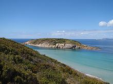
Shelter Island is approximately 20 kilometres (12 mi) due west of Albany, Western Australia.
Map of Shelter Island, Western Australia, Australia
It is often mistakenly referred to as Muttonbird Island. The island is approximately 130 metres (427 ft) off-shore from Muttonbird Beach separated by a channel that has an average depth of 8 metres (26 ft) it is regarded as a suitable open-water dive site.
The island consists of a mass of granite but has sufficient soil for plant growth and is well vegetated on top. The island supports breeding populations of flesh-footed shearwaters and little penguins as well as small populations of feral cats and black rats.
Little penguins have also been seen on the island.
The total area of the island is 10 hectares (25 acres). It was declared a Class 1A Nature Reserve in 1973.