
Elevation 6,847 ft (2,087 m) | Designated as world heritage site 1976 | |
 | ||
Location Adams County, Idaho,
United States Mountain type Lava flows of Columbia River Basalt Group Similar Seven Devils Mountains, Hells Canyon Dam, Hells Canyon National, Hells Canyon, Bear River | ||
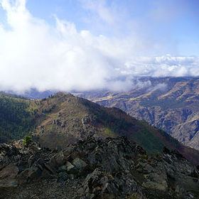
Sheep Rock is an overlook of Hells Canyon. It is located in the Payette National Forest about 45 miles northeast of Council, Idaho and was designated a National Natural Landmark in 1976. The formation consists of two contrasting series of layers from the Columbia River Basalt Group. The layers are separated by an unconformity and provide an unobstructed view of this type of geologic phenomenon.
Map of Sheep Rock, Idaho 83612, USA
Sheep Rock is named for the Bighorn Sheep that used to inhabit the area. To the north is part of Red Ledge Mine in Deep Creek. The National Forest maintains a mile long interpretive trail that leads to the canyon overlook halfway around the loop. Also at the trailhead is a campground with vault toilet.
Nearby is Kinney Point, an old lookout site over the canyon. It is just off the road to Sheep Rock about 1.5 miles south. The NFS has an interpretive site here.