
Prominence 1,122 ft (342 m) Elevation 3,426 m | ||
 | ||
Topo map USGS Blue Miner Lake, WY Similar Rocky Mountains, Gros Ventre Range, Jackson Peak, Bridger‑Teton National Forest, Mount Doane | ||
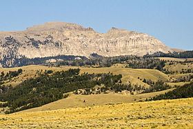
Sheep Mountain (11,239 feet (3,426 m)) is located in the U.S. state of Wyoming. Sheep Mountain forms a 5-mile (8 km) long ridge in the Gros Ventre Range and is easily seen from Jackson Hole. The town of Jackson, Wyoming is 13 miles (21 km) southwest of the peak. The southern end of Sheep Mountain is above the tree line and consists of rocky cliffs that are referred to as the "Sleeping Indian" due to their appearance as viewed from Jackson Hole. Sheep Mountain is in the Gros Ventre Wilderness of Bridger-Teton National Forest. At the northern end of Sheep Mountain is the location of the Gros Ventre landslide.
Map of Sheep Mountain, Wyoming 83011, USA
In 1996 an U.S. Air Force C-130 cargo plane carrying an automobile and equipment outbound from Jackson Hole crashed into Sheep Mountain, killing a U.S. Secret Service agent and eight Air Force personnel. The cargo plane was transporting equipment to another destination after U.S. President Bill Clinton and his family had vacationed in Jackson Hole the previous week.