
Country United States County Wallace FIPS code 20-64375 Elevation 1,059 m Zip code 67758 Population 788 (2013) | Time zone Mountain (MST) (UTC-7) GNIS feature ID 0471157 Area 236 ha Local time Friday 1:47 PM Area code 785 | |
 | ||
Weather 4°C, Wind E at 23 km/h, 95% Humidity | ||
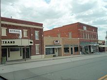
Sharon Springs is a city in and the county seat of Wallace County, Kansas, United States. As of the 2010 census, the city population was 748.
Contents
- Map of Sharon Springs KS 67758 USA
- History
- Geography
- Climate
- 2010 census
- 2000 census
- Transportation
- References
Map of Sharon Springs, KS 67758, USA
History
Sharon Springs was originally called Eagle Tail Station when it was founded in 1868. It was renamed Sharon Springs in 1886, after Sharon Springs, New York. Sharon Springs was incorporated as a city in 1890.
In 2013, the largest sinkhole in Kansas opened north of Sharon Springs. As of December 2013, the sinkhole was approximately 88 feet (27 m) deep and 243 feet (74 m) across.
Geography
Sharon Springs is located at 38°53′44″N 101°45′3″W (38.895513, -101.750881). According to the United States Census Bureau, the city has a total area of 0.91 square miles (2.36 km2), all land.
Climate
According to the Köppen Climate Classification system, Sharon Springs has a semi-arid climate, abbreviated "BSk" on climate maps.
2010 census
As of the census of 2010, there were 748 people, 327 households, and 197 families residing in the city. The population density was 822.0 inhabitants per square mile (317.4/km2). There were 407 housing units at an average density of 447.3 per square mile (172.7/km2). The racial makeup of the city was 94.5% White, 0.1% African American, 0.4% Native American, 3.6% from other races, and 1.3% from two or more races. Hispanic or Latino of any race were 5.7% of the population.
There were 327 households of which 27.2% had children under the age of 18 living with them, 51.7% were married couples living together, 6.1% had a female householder with no husband present, 2.4% had a male householder with no wife present, and 39.8% were non-families. 38.2% of all households were made up of individuals and 22.3% had someone living alone who was 65 years of age or older. The average household size was 2.23 and the average family size was 2.99.
The median age in the city was 45.3 years. 25.5% of residents were under the age of 18; 4.9% were between the ages of 18 and 24; 19.2% were from 25 to 44; 25.4% were from 45 to 64; and 25% were 65 years of age or older. The gender makeup of the city was 48.8% male and 51.2% female.
2000 census
As of the census of 2000, there were 835 people, 354 households, and 227 families residing in the city. The population density was 900.0 people per square mile (346.7/km²). There were 408 housing units at an average density of 439.8 per square mile (169.4/km²). The racial makeup of the city was 96.05% White, 0.24% African American, 0.48% Native American, 1.68% from other races, and 1.56% from two or more races. Hispanic or Latino of any race were 4.31% of the population.
There were 354 households out of which 29.7% had children under the age of 18 living with them, 57.3% were married couples living together, 3.7% had a female householder with no husband present, and 35.6% were non-families. 33.9% of all households were made up of individuals and 17.8% had someone living alone who was 65 years of age or older. The average household size was 2.29 and the average family size was 2.93.
In the city, the population was spread out with 24.2% under the age of 18, 7.9% from 18 to 24, 22.5% from 25 to 44, 21.3% from 45 to 64, and 24.1% who were 65 years of age or older. The median age was 42 years. For every 100 females there were 90.2 males. For every 100 females age 18 and over, there were 95.4 males.
The median income for a household in the city was $33,333, and the median income for a family was $43,684. Males had a median income of $27,500 versus $14,600 for females. The per capita income for the city was $17,656. About 4.3% of families and 7.3% of the population were below the poverty line, including 6.7% of those under age 18 and 10.8% of those age 65 or over.
Transportation
Sharon Springs is located on U.S. Route 40.