
Time zone IRST (UTC+3:30) | County Basht Population 26 (2006) | |
 | ||
Province Kohgiluyeh and Boyer-Ahmad Province | ||
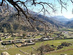
Shadegan (Persian: شادگان, also Romanized as Shādegān ([ʃɒːdeɡɒːn]), locally known as Goru (گورو) or Gowrū ([ɡouɾuː])) is a village in Kuh Mareh Khami Rural District, in the Central District of Basht County, Kohgiluyeh and Boyer-Ahmad Province, Iran. At the 2006 census, its population was 26, in 8 families.
Contents
Map of Shadegan, Kohgiluyeh and Boyer-Ahmad Province, Iran
Shadegan is located alongside a valley behind one of the Zagros Mountains locally called the Khoomi Mountains. This village is about 40 km from the nearest city Gachsaran (population: 70,422, 2nd largest city in the province) and its rich oilfields of Be Be Hakemeh and Gureh. Shadegan village is a few hundred kilometres distance from the town of Shadegan, Khuzestan province.
The Shadegani people speak the Lurish language which is one of the western Iranian languages. Within Iran, the Kurds, Lurs of Luristan (northern Luristan), Lurs of Bakhtiari and Lurs of Kohgiluye and Boyer-Ahmad are living on-and-around these mountains from west to east for generations. The local name for Shadegan was Goru but for unknown reasons it has been recorded under the name of Shadegan in the Governmental registries.
Shadegan has a relatively untouched natural beauty including a river called Roo Bashti (Persian: رود باشتی). Near to Shadegan are the tombs of the Do Pir-e-Jofteh (Persian: دو پیر جفته, meaning "The Pair of Pirs (Old Men)" or "The Two Old Men").
In 1960, the estimated population of the village was 100 people. As of 2010, the population of the village is not estimated to be more than 10 full-time residents. Currently all estimated 10 residents of Shadegan have access to a landline telephone which is supervised and looked after one of the village elders, Mr Nurullah Hashemi, Son of marhoom Ka Zameni. However mobile and radio reception are poor and TV and Internet reception are still non-existent and they hope the authorities provide them with such basic technology.
Many former residents of Shadegan, who now live in cities across Iran, gather once a year on the thirteenth day after the Persian New year, Nowruz, in the village during the celebration of Sizdah Bedar.
History
Shadegan was one of the villages in that region which was run by the local ruler, the Khan (Persian: خان, meaning warlord, lord, landlord ), who was dictating his will under the strict rules of Feudalism, until the estimated twenty peasant families, like other peasants in many parts of Iran, were liberated under the slogan of the White Revolution, which were a series of socio-economic policies implemented by the Shah at the behest of the administration of U.S. President John F. Kennedy in 1963. In anticipation for these land reforms, in 1958, some children from Shadegan, along with other villages, were for the first time in their history able to attend school. In 1970 Shadegan was moved towards the road from Basht to Cheram when roads were first constructed in the area.
Since change of government in 1979 most of the inhabitants of Shadegan have left the village, going to the city, mostly to nearby Gachsaran and Shiraz with some moving to the capital (Tehran).