
Topo map OS Landranger 33, 40 Prominence 839 m | OS grid NM902966 Elevation 1,040 m Parent peak Càrn Eige | |
 | ||
Pronunciation Scottish Gaelic: [ˈs̪kuːrˠ nə ˈkʰʲiːçə] Similar Sgùrr Mòr, Ladhar Bheinn, Sgùrr Thuilm, Gleouraich, Sgùrr a' Mhaoraich | ||
Sgùrr na Cìche is a mountain in the Knoydart region, in the west of Scotland. It lies on the edge of Knoydart in an area known as the Rough Bounds of Knoydart.
Map of Sgurr na Ciche, Invergarry, UK
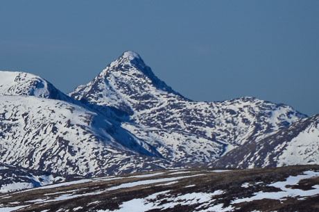
The peak has a distinctive pointy shape, making it a recognisable object in views from many of Scotland's mountains, including Càrn Eige and Ben Nevis. Its close neighbours include Ladhar Bheinn and The Saddle, but thanks to the deep gulf separating it from them, it has a high prominence — the 25th highest in Britain.
Sgùrr na Cìche may be climbed from the head of Loch Nevis on the southern side of Knoydart by following the ridge of Druim a' Ghoirtein. However, due to the remoteness of the Knoydart peninsula, it is more commonly climbed as part of a circuit from the head of Glen Dessarry, via a route that also takes in the neighbouring Munros of Garbh Cìoch Mhòr and Sgùrr nan Coireachan.