
- left Zamantı - elevation 1,500 m (4,921 ft) Length 560 km Mouth Mediterranean Sea Cities Adana | - location Aladağ, Adana, Turkey - location Tarsus, Mersin, Turkey Basin area 20,600 km² Country Turkey | |
 | ||
Bridges Taşköprü, Demirköprü, Şekerpınarı Bridge, Devlet Bahçeli Bridge Provinces Kayseri Province, Adana Province, Mersin Province | ||
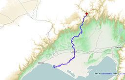
The Seyhan River (formerly written Seihan, Sihun; ancient name: Σάρος, Sarus) is the longest river in Turkey that flows into the Mediterranean Sea. The river is 560 km and flows southwest from its headwaters in the Tahtalı-Mountains (in Sivas and Kayseri provinces) in the Anti-Taurus Mountains to the Mediterranean Sea via a broad delta. Its main tributaries are Zamantı and Göksu, which unite in Aladağ, Adana to form the Seyhan River. The Zamantı River originates from the Uzun Plateau in Pınarbaşı, Kayseri and crosses Tomarza, Develi and Yahyalı districts in Kayseri.
Map of Seyhan River, Turkey
In ancient times, it was called the Sarus, and its plain was called the Cilician plain.
50 km from its mouth, Seyhan River flows through the city of Adana, the only settlement situated on the river. Several bridges and footbridges cross the river in Adana including the Stone Bridge, a 4th-century Roman bridge. The river meets the Mediterranean Sea at Cape Deli.
The major Seyhan Dam upstream of Adana serves for irrigation, hydroelectric power, and flood control. Yedigöze, Çatalan and Kavşak Bendi are the other dams on Seyhan River which also serve the same purposes. The river is currently under extensive development for hydroelectric power and irrigation.