
Elevation 301 m (988 ft) Area 553.3 km² Local time Thursday 3:46 AM | Founded November 6, 1556 Time zone UTC-3 (UTC-3) Population 112,555 (2010) | |
 | ||
Weather 22°C, Wind SW at 14 km/h, 74% Humidity Colleges and Universities FASE Faculty, Faculty of Centro Leste | ||
Serra is a municipality in the state of Espírito Santo, Brazil. Bordering the north of the state's capital, Vitória, the municipality is part of the Greater Vitória metropolitan area. Its population was 409,324 (2010) and its area is 553 km².
Contents
Map of Serra, State of Esp%C3%ADrito Santo, Brazil
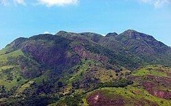
Serra, the seat of the municipality, is to the north of the characteristic Mestre Álvaro mountain which juts out of the coastal lowlands, and which is said to look like a small mountain range or "serra", in Portuguese, which is where the town and municipality got its name.
Politically
Serra has five districts (distritos): Serra-Capital (or Serra-Sede), Carapina, Calogi, Nova Almeida and Queimado. Among those districts there are 118 neighbourhoods (bairros).
Another important urban area is that of Jacaraípe, on the coast 20 km north of Vitória. Jacaraípe is very well known for surfing championships, and is a weekend beach used by capital dwellers. Other smaller fishing villages such as Manguinhos are also close enough for day trips and are popular destinations for the locals.
The coastline of the municipality is protected in part by the 112,545 hectares (278,100 acres) Costa das Algas Environmental Protection Area, created in 2010.