
Intercommunality Auzat-Vicdessos Area 5.22 km² | Region Occitanie Canton Sabarthès Population (2008) 29 Local time Monday 4:35 AM | |
 | ||
Weather 2°C, Wind S at 5 km/h, 66% Humidity | ||
Geography and sights
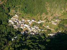
The Sem village lies in the Vicdessos valley at 991 meters above sea level. It is an old mining village, tied with the history of the iron mining of Rancié. The stream of Sem forms a huge waterfall (Carraoucou waterfall) and a cone. A big rock called "the dolmen" of Sem was made by a former glacier.
Population
Inhabitants of Sem are called Sémois.
References
Sem, Ariège Wikipedia(Text) CC BY-SA