
Peak Hohe Egge (Selter) Length 11 km (6.8 mi) Country Germany | Elevation 395 m (1,296 ft) | |
 | ||
Types of rock Limestone, Marl, Siltstone, Sandstone Ages of rock Middle Jurassic, Late Jurassic Periods Middle Jurassic, Late Jurassic Similar | ||
The Selter is a ridge, up to 395 m above NN, in the Lower Saxon Hills in the districts of Hildesheim, Holzminden and Northeim in the German state of Lower Saxony.
Contents
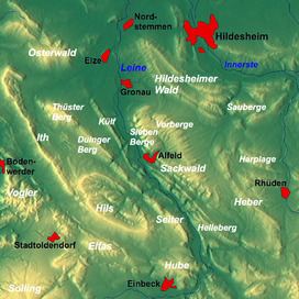
Map of Selter, 31073 Delligsen, Germany
Location
The Selter is a narrow ridge in the Alfeld Uplands, part of the Leine Uplands in the Lower Saxon Hills. It is about 11 kilometres long and lies in the rectangle formed by the villages of Alfeld, Freden, Kreiensen and Delligsen. It lies between Delligsen to the northwest, Imsen to the north, Freden to the east, Erzhausen to the southeast, Greene to the south-southeast, Naensen to the south, Stroit and Ammensen to the southwest and Varrigsen to the west. Its virtual centre lies near Freden.
Hills
Amongst the hills of the Selter are the following − sorted by height in metres above sea level (NN)