
Postcode(s) 5174 LGA(s) City of Onkaparinga Sellicks Beach Sellicks Hill Local time Monday 11:37 AM | Time zone ACST (UTC+9:30) State electorate(s) Finniss Postal code 5174 Federal division Division of Kingston | |
 | ||
Population 2,339 (2011 census Census) Weather 20°C, Wind W at 31 km/h, 63% Humidity | ||
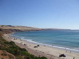
Sellicks Beach is an outer southern suburb of Adelaide, South Australia which is located in the local government area of the City of Onkaparinga and is the southernmost extent of the Adelaide metropolitan area. At the 2006 census, Sellicks Beach had a population of 2,339.
Contents
Map of Sellicks Beach SA 5174, Australia
There are housing development projects being undertaken in Sellicks Beach. There is a post office, delicatessen and a wholesale nursery. Sellicks Beach is also close to Aldinga Beach, a 10-minute drive, which has two petrol stations, two supermarkets, bakery, doctors surgery, two chemists and other various shops. Driving on the beach is permitted free of charge for residents while a non-residents are charged a small fee.
Max temp history
Hottest Ever This Month - 31.5° 27/09/2008
Hottest This Year - 37.9° 06/03/2016
Hottest This Month - 24.4° 07/09/2016
Long Term Average - 18.8°
Average This Month - 16.9°
Hottest September On Record - Avg. max. temp. 21.2° (2013)
Min temp history
Coldest Ever - 4.0° 11/09/2002
Coldest This Year - 4.0° 17/07/2016
Coldest This Month - 8.1° 14/09/2016
Long Term Average - 10.5°
Average This Month - 10.3°
Coldest September On Record - Avg. max. temp. 9.1° (2003)