
- land 1.2 sq mi (3 km) Area 3.108 km² Local time Sunday 9:03 PM | - summer (DST) EDT (UTC-4) Zip code 18960 Population 4,241 (2013) | |
 | ||
- water 0.04 sq mi (0 km), 3.33% Weather 4°C, Wind E at 13 km/h, 96% Humidity | ||
Sellersville is a borough in Bucks County, Pennsylvania, United States. The population was 4,249 at the 2010 census. Sellersville is part of Pennridge School District.
Contents
Map of Sellersville, PA 18960, USA
History
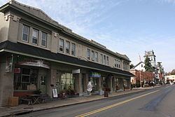
Sellersville was founded in the early 18th century. It was centered on a major road known as Bethlehem Pike that connected Philadelphia to Bethlehem and the rest of what was then far Western Pennsylvania. The town was very small and was called Sellers Tavern. Its most notable feature was a large inn. The present Washington House in Sellersville, however, was not Sellers Tavern. The town grew slowly over the years until the Industrial Revolution. In the 1860s the North Pennsylvania Railroad was built, running parallel to Bethlehem Pike: this stimulated the growth of light textile industries and brought a wave of population growth. The East Branch of the Perkiomen Creek runs through the town which connects it to an adjacent town of Perkasie. This creek was dammed in the early 20th century creating a small body of water known as Lake Lenape. Along the length of the lake a park was built on Perkasie and Sellersville lands. In the 1920s and 1930s this park housed a carousel, a roller coaster and several other amusements. The railroad brought hundreds of people from Philadelphia in the summer time, and it became a well known vacation spot for blue collar city workers. The town was also home to the Radium Company of America, which was the largest uranium milling facility in the world at the time. The United States Gauge Company originated in Sellersville in 1904 and became a prominent manufacturer of gauges for military use, many of which were coated with radium-based paint for nighttime luminesence. The company later became instrumental in the production of nuclear weapons, leaving behind a legacy of industrial and radioactive contamination that has been well-hidden by local, county, state, and federal government agencies for decades. Today the town is still relatively small, sandwiched in between a ridge line and the larger town of Perkasie. The center of town still runs along Bethlehem Pike which is now called Old Route 309. The Washington House still stands and has recently been restored to become an upscale restaurant. Next door to the restaurant was a livery stable, which was converted into a theater (later a movie theater) in 1894. It has since been restored, and reopened in 2001 as Sellersville Theater 1894- a popular live music venue. The creek is still dammed but only the carousel in Perkasie remains of the amusements. The textile industry has long moved out of the area and Sellersville has become mainly a residential town for people working in the many urban centers that are only a short commute away. Grand View Hospital, Bucks County’s first hospital, has provided residents of Bucks and Montgomery counties with comprehensive healthcare services since 1913. The town is surrounded on three sides by open country and spread out housing developments. The local firehouse provides various activities throughout the year, including a carnival in the summer. The Holiday House Pool and Recreation Center becomes a hotspot for people to escape the heat during the summer as well. There are various business along Main Street one of which is the Washington House. This strip of businesses along Main Street provide some jobs as well, but largely the town remains a residential area. There is a Sellersville Museum off of Main Street which displays different exhibits every month.
The Teller Cigar Factory was listed on the National Register of Historic Places in 1987.
Geography
According to the United States Census Bureau, the borough has a total area of 1.2 square miles (3.1 km2), of which, 1.2 square miles (3.1 km2) of it is land and 0.04 square miles (0.10 km2) of it (1.69%) is water. It is located in Southeastern Pennsylvania as part of Northern Bucks County (colloquially referred to as Upper Bucks) which borders Northampton County,and Lehigh County.
Demographics
As of the census of 2010, there were 4,249 people residing in the borough. The racial makeup of the borough was 93.6% White, 1.8% African American, 0.3% Native American, 1.0% Asian, 0.0% Pacific Islander, 1.0% from other races, and 2.3% from two or more races. Hispanic or Latino of any race were 3.4% of the population.
As of the census of 2000, there were 4,564 people, 1,770 households, and 1,198 families residing in the borough. The population density was 3,934.1 people per square mile (1,519.1/km²). There were 1,827 housing units at an average density of 1,574.8 per square mile (608.1/km²). The racial makeup of the borough was 97.30% White, 0.57% African American, 0.15% Native American, 0.35% Asian, 0.04% Pacific Islander, 0.48% from other races, and 1.10% from two or more races. Hispanic or Latino of any race were 1.99% of the population.
There were 1,770 households, out of which 36.8% had children under the age of 18 living with them, 53.1% were married couples living together, 11.0% had a female householder with no husband present, and 32.3% were non-families. 26.5% of all households were made up of individuals, and 5.9% had someone living alone who was 65 years of age or older. The average household size was 2.56 and the average family size was 3.13.
In the borough the population was spread out, with 27.6% under the age of 18, 8.2% from 18 to 24, 36.9% from 25 to 44, 19.1% from 45 to 64, and 8.2% who were 65 years of age or older. The median age was 34 years. For every 100 females there were 101.1 males. For every 100 females age 18 and over, there were 95.9 males.
The median income for a household in the borough was $46,500, and the median income for a family was $55,313. Males had a median income of $38,018 versus $27,056 for females. The per capita income for the borough was $19,970. About 5.4% of families and 5.2% of the population were below the poverty line, including 6.5% of those under age 18 and 5.6% of those age 65 or over.
Notable people
Notable current and former residents of Sellersville include:
Transportation
Sellersville was once served by the SEPTA Bethlehem Line.