
Country France River mouth Somme River Basin size 610 km (240 sq mi) Discharge 4.5 m³/s | Main source Catheux Progression Somme→ English Channel Length 39 km Basin area 610 km² | |
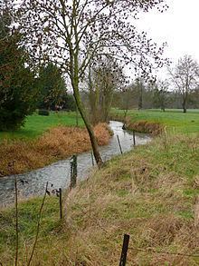 | ||
The Selle (also spelt Celle in the Oise) is a river of Picardy, France. Rising at Catheux, just north of Crèvecœur-le-Grand, Oise, it flows past Conty, Saleux, Salouël and Pont-de-Metz before joining the Somme River at Amiens.
In many places along its course, the river widens to form or fill lakes, much appreciated by anglers and gravel extractors. Several water-powered mills can still be seen including a paper-mill at Prouzel. Brown trout thrive in the clear waters of the river.
History
In 57 BC, the Selle was the site of the battle between Julius Caesar and the Nervians.
In World War I, during the Hundred Days Offensive of 1918, the German Army had taken up positions along the Selle near Le Cateau. General Rawlinson's Fourth Army spent two weeks preparing to assault these positions. The attack was launched on the night of 17 October when the river was crossed in foggy conditions and continued until the Germans were finally forced to retire on 20 October. The action is known as the Battle of the Selle.