
 | ||
Similar | ||
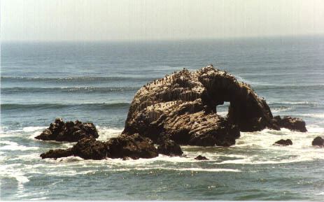
Seal Rocks is a group of small rock formation islands in the Lands End area of the Outer Richmond District in western San Francisco, California. They are located just offshore in the Pacific Ocean, at the north end of the Ocean Beach, near the Cliff House and Sutro Baths ruins.
Contents
Map of Seal Rocks, San Francisco, CA, USA
The name is derived from the population of Steller's sea lions (Eumetopias jubatus) and California sea lions (Zalophus californianus), who used to haul out on the rock. Both species are often colloquially called "seals". The formations and wildlife are protected within the NPS Golden Gate National Recreation Area.
Geology
Near the end of the last ice age, this part of the coastline was thought to be between eight and twenty five miles westward of its current position - around five thousand years ago, with the melting of the ice, the sea level rose to its current level.
The coastal features found here today were formed by the actions of waves, wind, and the movement of sand. The geology of this part of the coastline of San Francisco consists of steep rocky cliffs which are punctuated by narrow sandy pocket beaches found at the north end of the city and long sandy stretches at Ocean Beach and Fort Funston to the south. The local features, and indeed the entire San Francisco Peninsula, come from the northern aspect of the Santa Cruz Mountains. Before the urban development seen today, the area landward of Ocean Beach consisted of barren sand fields inland to Twin Peaks. The first known map of the area, dating from 1852, was made by the U.S. Coast and Geodetic Survey and describes the coastline here as being entirely unaltered by humans.
The geologic layers beneath Ocean Beach, starting from the top (i.e. the youngest), are:
The Colma and Merced Formations consist generally of poorly-sorted sandy deposits, probably deposited during some earlier period of greater sea levels. The Colma Formation is found under the dune sands and also extends inland.