
Type Reservoir Primary outflows Deer Creek Surface area 850 acres (340 ha) Area 3.44 km² | Primary inflows Surface elevation 936 m Settlement Scotts Flat Lake | |
 | ||
Location Tahoe National ForestNevada County, California Similar Sierra Nevada, Rollins Dam, Camp Far West Reservoir, Boca Reservoir, Lake Amador | ||
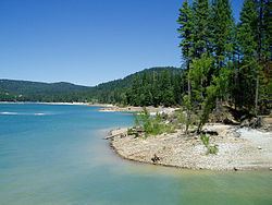
Scotts Flat Reservoir is an artificial lake in the Tahoe National Forest of Nevada County, California, 6.5 miles (10.5 km) east of Nevada City. The lake is at an elevation of 3,100 ft (940 m) and has a surface area of 850 acres (340 ha), with 7.5 miles (12.1 km) of shoreline lined with pine trees. Amenities consist of two launch ramps, a marina, campsites, a picnic area, sandy beaches, and a general store.
Map of Scotts Flat Reservoir, California 95959, USA
The earthen rock-fill Scotts Flat Dam dates from 1948 and impounds Deer Creek to create the reservoir with a capacity of 49,000 acre-feet. At 175 feet above streambed, the dam is owned and operated by the county-level Nevada Irrigation District.
References
Scotts Flat Reservoir Wikipedia(Text) CC BY-SA