
Country United States County Oswego FIPS code 36-65618 Elevation 120 m Population 8,501 (2010) Area code 315 | State New York Time zone Eastern (EST) (UTC-5) GNIS feature ID 0979471 Zip code 13135 Local time Friday 10:04 AM | |
 | ||
Weather 2°C, Wind S at 14 km/h, 86% Humidity Area 111.9 km² (109.6 km² Land / 233 ha Water) | ||
Schroeppel is a town in Oswego County, New York, United States. The population was 8,501 at the 2010 census. The name derives from the Schroeppel family, early land owners of the area. Schroeppel is located in the southeast part of the county.
Contents
- Map of Schroeppel NY USA
- History
- Geography
- Demographics
- Communities and locations in Schroeppel
- References
Map of Schroeppel, NY, USA
History
The town of Schroeppel was formed in 1832 from the town of Volney.
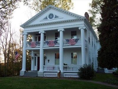
The Schroeppel House was listed on the National Register of Historic Places in 1982.
Geography
The southwest town line, marked by the Oneida River, is the border of Onondaga County, New York. The southwest town line is partly formed by the Oswego River. The Erie Canal is on the south border of the town.
According to the United States Census Bureau, the town has a total area of 43.2 square miles (112 km2), of which, 42.3 square miles (110 km2) of it is land and 0.9 square miles (2.3 km2) of it (2.01%) is water.
Demographics
As of the census of 2000, there were 8,566 people, 3,251 households, and 2,347 families residing in the town. The population density was 202.4 people per square mile (78.2/km²). There were 3,590 housing units at an average density of 84.8 per square mile (32.8/km²). The racial makeup of the town was 97.79% White, 0.39% African American, 0.68% Native American, 0.30% Asian, 0.09% from other races, and 0.75% from two or more races. Hispanic or Latino of any race were 0.84% of the population.
There were 3,251 households out of which 36.9% had children under the age of 18 living with them, 55.6% were married couples living together, 12.0% had a female householder with no husband present, and 27.8% were non-families. 22.6% of all households were made up of individuals and 9.4% had someone living alone who was 65 years of age or older. The average household size was 2.63 and the average family size was 3.06.
In the town, the population was spread out with 28.1% under the age of 18, 7.2% from 18 to 24, 30.6% from 25 to 44, 23.9% from 45 to 64, and 10.1% who were 65 years of age or older. The median age was 36 years. For every 100 females there were 99.0 males. For every 100 females age 18 and over, there were 94.1 males.
The median income for a household in the town was $39,662, and the median income for a family was $45,766. Males had a median income of $31,191 versus $27,864 for females. The per capita income for the town was $17,581. About 7.7% of families and 9.7% of the population were below the poverty line, including 12.4% of those under age 18 and 12.4% of those age 65 or over.