
Traversed by Unimproved road Elevation 3,263 m | Topo map USGS Snowmass Mountain | |
 | ||
Similar Kebler Pass, The Trailhead Children, Crested Butte Mountain, Crested Butte Nordic, Crystal Mill | ||
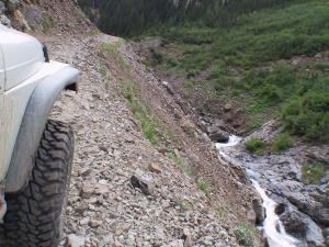
Schofield Pass, elevation 10,707 ft (3,263 m), is a mountain pass in the Elk Mountains of Colorado. The pass is the high point on Gothic Road, which connects the towns of Marble and Crested Butte. The road to the summit is suitable for a passenger car if traveling from the east; however, after this it is rated 4-wheel drive only as it switchbacks down the west side through the Devil's Punchbowl Canyon and becomes a narrow, rocky shelf road.
Map of Schofield Pass, Colorado 81654, USA
The pass is closed for most of the year due to snow or mud, and is open only for one or two months in late summer. Parking is available in the town of Crystal, and 4WD high-clearance trucks can continue two miles to the hiking trailhead at 9,700 feet. The road is accessible only by high-clearance 4-wheel-drive trucks from this side. Two miles from the trailhead lies Geneva Lake.
The pass has claimed 12 lives to date.
Schofield Pass was named for B. F. Schofield, a silver miner.