
Population 1,194 (2011) Sovereign state United Kingdom | Civil parish Scarcroft Local time Thursday 11:18 PM Dialling code 0113 | |
 | ||
Weather 3°C, Wind N at 14 km/h, 91% Humidity | ||
Scarcroft is an upmarket village and civil parish 6 miles (10 km) north east of Leeds city centre in the City of Leeds metropolitan borough, West Yorkshire, England. The village lies on the main A58 road between Leeds and Wetherby. Scarcroft has a LS14 postcode and two of the most expensive streets in Yorkshire and the Humber - Ling Lane and Bracken Park. It has a population of 1,153 increasing to 1,194 at the 2011 Census.
Map of Scarcroft, Leeds, UK
The village of Bardsey is further 1 mile (2 km) eastwards on the A58 towards Wetherby.
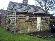
The Scarcroft Watermill was built in 1810 to grind corn.
There is one pub in Scarcroft, the New Inn, established in 1852. It was at one time called The Bracken Fox but reverted to its former name in 2011. The village's shop and post office have closed. The closest local shops are in Bardsey, Shadwell and Whinmoor. The closest supermarkets are Tesco in Seacroft and Morrisons in Wetherby. Scarcroft is also renowned for having among the most expensive streets in Leeds; Bracken Park - recently revealed as the most expensive - and Ling Lane, regularly appearing in top ten lists.