
Barangays ZIP code 5002 | District 2nd district of Iloilo Time zone PST (UTC+8) Area 132 km² | |
 | ||
Neighborhoods Lanag, Guno, Bitaog-Taytay | ||
Explore iloilo santa barbara iloilo
Santa Barbara is a first class municipality in the province of Iloilo, Philippines. According to the 2015 census, it has a population of 60,215 people. It is located in the center of Iloilo, 15 kilometres (9.3 mi) from Iloilo City.
Contents
- Explore iloilo santa barbara iloilo
- Map of Santa Barbara Iloilo Philippines
- New santa barbara heights subdivision video 1 of 2 santa barbara iloilo philippines
- Geography
- Land Use
- Climate
- Barangays
- History
- Demographics
- Transportation
- Landmarks
- References
Map of Santa Barbara, Iloilo, Philippines
New santa barbara heights subdivision video 1 of 2 santa barbara iloilo philippines
Geography
Santa Barbara has a land area of 13,196 hectares (32,610 acres), ranks 29th as to size among the 42 municipalities of the province and occupies 1.5% of all lands in the Province of Iloilo. Almost 100% of Santa Barbara’s land is cultivated and alienable or disposable.
The topography of Santa Barbara varies from slightly rolling hills to almost flat or gradually inclined plains, sliced by Tigum River at its centremost, which flows from the north-west to the southeast and the Aganan River in the southern section.
Land Use
Basically, Santa Barbara is an agricultural town with 84.75% or 6,568.19 hectares (16,230.4 acres) devoted to agriculture. The rolling hills, amounting to 155.99 hectares (385.5 acres), are unsuitable to farming and are utilized as pasture and open grassland. The built-up areas within the poblacion and the barangay areas total 678.98 hectares (1,677.8 acres) or 8.761%. Also included in this category are the areas utilized for commercial, institutional purposes, parks and open space. Agro-industrial area is 101.928 has. or 1.315%, industrial area is .069 % or 5.330 has., utilities or roads comprise 150.853 has. or 1.946% . The area for the cemeteries is 4.720 has. or .061 % and bodies of water is 1.084% or 84 hectares.
Climate
There is a distinct climate in this municipality, which is deal for planting of multiple crops. It has a type “C” (moist ) rain sufficiently distributed with almost 4 ½ dry months or first –type climate with two distinct seasons of six months.
The average annual rainfall is 137.47 centimetres (54.12 in). The average temperature is 27.9 °C (82.2 °F). This municipality is not within the country’s typhoon belt although tropical storms and occasional typhoons pass thru it.
Barangays
Santa Barbara is politically subdivided into 60 barangays.
History
The Agustinian Archives, Vol. 17-18, which recorded the missionary achievements of the Agustinian missionaries, mentions that in 1617 the missionaries ministered a community then known as Catmon, a name derived from a fruit tree which was an imposing landmark, which sat on a rich and fertile plain traversed by the Salug (now Tigum) and Aganan rivers, producing rice, corn, sugar, mongo and tobacco. Then Catmon was only a “Visita Catmon” of Jaro vicariate.
In 1760, Catmon was established as an independent parish, whose patron saint was Santa Barbara and the settlement became a “pueblo” named after her. Its total population at the time was 15,094.
In 1845, its population was 19,719 and it covered an area which are now the Municipalities of Maasin, Janiuay, Cabatuan, Alimodian, San Miguel, Zarraga, New Lucena and parts of Leganes and Pavia.
When the Philippine Revolution broke out on Luzon in 1896, it did not spread immediately to Iloilo. The Spanish authorities thought that they could keep the Ilonggos loyal to Spain. Governador–General Basilio Agustin organized the Volunteer Militia in Iloilo to enlist Ilonggos to fight the Tagalog rebels. Being a “mestizo” and having occupied the highest office in his town, Martin Teofilo Delgado was appointed commander of the “voluntaries” in Santa Barbara.
Unknown to the Spaniards, however, Delgado had already become a “revolucionario”. On October 28, 1898 he publicly declared himself for the Revolution and seized the municipal building. The Revolutionary Government of the Visayas was organized and on November 17, 1898, was formally inaugurated at the town plaza of Santa Barbara. A large crowd hailing from many places across Iloilo gathered for the historic occasion. The Philippine flag was raised for the first time outside of Luzon.
The officials of the Revolutionary Government were Roque Lopez, president; Vicente Franco, vice president and secretary of the interior; Venancio Concepcion, secretary of finance; Ramon Avanceňa, secretary of state; Jovito Yusay, secretary of justice; Julio Hernandez, secretary of war; Fernando Salas, secretary general. General Martin T. Delgado was chosen General –in-Chief of the Revolutionary Forces.
Santa Barbara became the headquarters of the Revolutionary Forces and from here, Gen. Delgado launched the campaign to liberate the whole province which culminated in the surrender of Iloilo City by Governor-General de los Rios on December 24, 1898.
The victory against Spain was short-lived as the Philippine–American War followed. Gen. Delgado led the same army against Americans from 1899 to 1901. Delgado was forced to surrender on February 2, 1901.
Upon the establishment of the civil government, Martin Delgado was appointed as the first provincial Governor of Iloilo and was elected to the same position in the first elections held in 1903. Santa Barbara became a town under American regime and was incorporated into a municipality by the Commonwealth Government. The town soon began to progress.
In 1948, Barangay Tuburan-Solbud was transferred to Zarraga, Iloilo.
Demographics
In the 2015 census, the population of Santa Barbara, Iloilo, was 60,215 people, with a density of 460 inhabitants per square kilometre or 1,200 inhabitants per square mile.
Majority of the people or about 73.25% of the population are Kinaray-a speaking, a dialect that originated in the province of Antique. The remaining population speaks in Hiligaynon, Filipino, and English.
Transportation
The total road network is 159.60 kilometres (99.17 mi); 117.20 kilometres (72.82 mi) of which are barangay roads, 25.49 kilometres (15.84 mi) provincial roads, 9.06 kilometres (5.63 mi) municipal streets and 7.85 kilometres (4.88 mi) national highways.
In July 2007, the new Iloilo International Airport, located in Cabatuan and Santa Barbara, Iloilo was opened to the public. As a result, access to air transportation has significantly improved. Before, the plying of taxis in the Municipality is an uncommon sight to most Sta. Barbaranhon’s but with the construction and operation of the New Iloilo Airport the town started progressing economically more and more every year.
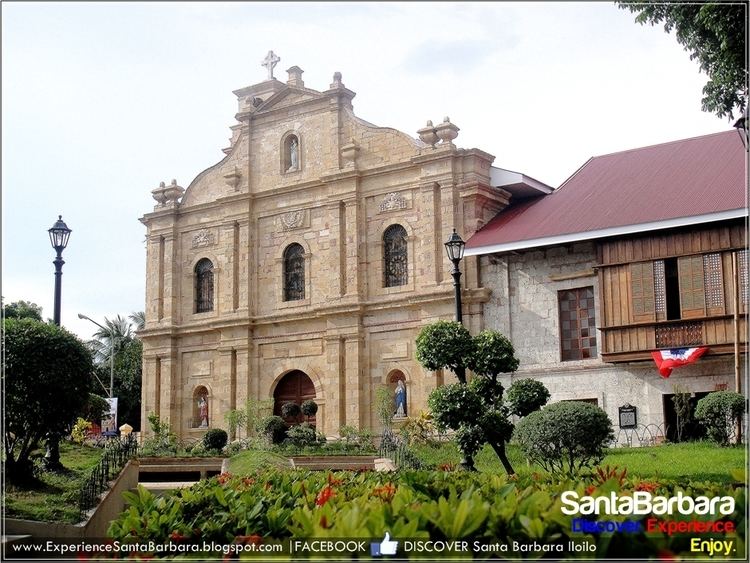
Landmarks
The Santa Barbara plaza is one of the finest, and most beautiful plazas in the Philippines. It is also where the Seat of the Republic of the Visayas was declared in November 17, 1898, headed by president Roque Lopez. The plaza was also the site where the first Philippine flag was raised outside Luzon in December 25, 1898 followed by the plaza libertad in Metro Iloilo also in the same date. The plaza was also declared as a Historical Landmark in 2015.