
Admin. region Freiburg Time zone CET/CEST (UTC+1/+2) Local time Tuesday 7:27 PM Postal code 79271 Administrative region Freiburg | Elevation 716 m (2,349 ft) Area 35.93 km² Population 2,541 (31 Dec 2008) Dialling code 07660 | |
 | ||
Weather 5°C, Wind NW at 11 km/h, 95% Humidity | ||
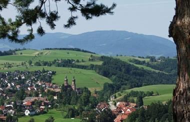
Sankt Peter is a municipality in the district of Breisgau-Hochschwarzwald in Baden-Württemberg in Germany.
Contents
Map of 79271 Sankt Peter, Germany
Location
St. Peter is a climatic spa located within the Southern Black Forest Nature Park, on the southern flank of the Kandel, about 12 miles east of Freiburg im Breisgau.
Administrative structure
To the municipality of St. Peter belong the village Bürgerschaft, the hamlet Sägendobel, the localities Kandelberg, Neuwelt, Oberibental, Ränke, Rohr, Schmittenbach, Schönhöfe, Seelgut and Willmendobel as well as the farms Eckpeterhof, Langeck and Lindlehof.
References
Sankt Peter, Baden-Württemberg Wikipedia(Text) CC BY-SA