
Length 23 km | Country United States of America | |
 | ||
River mouth Confluence with the South Platte5,095 ft (1,553 m) Progression | ||
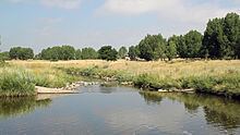
Sand Creek is a 14.6-mile-long (23.5 km) tributary that flows into the South Platte River near Commerce City, Colorado. From its source in unincorporated Arapahoe County, it flows through Aurora and Denver before joining the South Platte in Adams County.
Contents
Map of Sand Creek, Colorado, USA
Benzene pollution in Sand Creek
In November 2011, a local fisherman noticed an oily sheen on the surface of Sand Creek. Testing found the water of Sand Creek to be contaminated with abnormal levels of the aromatic hydrocarbon, benzene. The source of the benzene was a damaged pipe at the nearby Suncor refinery, from which benzene had seeped into the groundwater and surfaced at Sand Creek. In December 2011, the Colorado Department of Health and Environment began to monitor benzene levels at the junction of Sand Creek and the South Platte River. The results showed benzene levels ranging from 140 ppb to 730 ppb – far above the national EPA limit of 5 ppb. Further downriver in the South Platte, benzene levels were also found to be significantly elevated, ranging from 130 ppb to 190 ppb. Although the source of the benzene has been fixed, levels still remain above the EPA standard for drinking water. This is of concern because the South Platte River is drawn on for drinking water by nearby communities and is frequently used for recreational activities such as swimming and fishing.