
Area 14.7 km² Local time Monday 7:10 PM | Elevation 795 m Population 75,635 (2007) | |
 | ||
Weather 26°C, Wind N at 27 km/h, 49% Humidity Neighborhoods Colonia Los Andes, Colonia Santa Leonor | ||
San Marcos is a city in El Salvador. It is located in a small valley, 5 miles (8 km) southeast of downtown San Salvador. Its population is 63,209 inhabitants[1]. San Marcos is one of the 14 municipalities which make up the Metropolitan Area of San Salvador, also known as Greater San Salvador.
Map of San Marcos, El Salvador
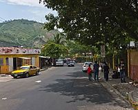
The city's geography is characterized by numerous small hills, as well as its proximity to Mount San Jacinto to the north and Planes de Renderos hills to the south. Most of San Marcos is a residential suburb with many middle-income and low-income dwellings. The city is the main gateway for air travelers because it is bordered by the Comalapa Highway (RN-5_(Autopista_Comalapa)), the freeway that connects El Salvador International Airport with San Salvador.
Not much commerce exists outside the municipal public market and the southeast bus station, however, there is a significant textile industry in the San Marcos Free Trade Zone, and logistic/distribution companies along the Comalapa Highway. The city's per capita GDP(PPP) is US $5,480 and it has a Human Development Index of 0.759 as of 2002 [2].