
Time zone UTC -3 Dial plan +598 4399 (+4 digits) Local time Monday 7:08 PM | Postal code 91300 Population 4,510 (2011) | |
 | ||
Weather 21°C, Wind SE at 34 km/h, 75% Humidity | ||
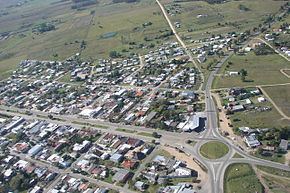
San Jacinto is a small city in the Canelones Department of southern Uruguay.
Contents
Map of San Jacinto, Canelones Department, Uruguay
San Jacinto is also the name of the municipality to which the city belongs.
Location
The city is located on the intersection of Route 7 with Route 11, about 53 kilometres (33 mi) northeast of the centre of Montevideo.
History
On 20 June 1901, its status was elevated to "Pueblo" (village) by the Act of Ley Nº 2.700. On 27 June 1951 it was further elevated to "Villa" (town) by the Act of Ley Nº 11.689. Finally, on 26 November 1976, its status was elevated to "Ciudad" (city) by the Act of Ley Nº 14.605.
Population
According to the 2011 census, San Jacinto had a population of 4,510. In 2010 the Intendencia de Canelones had estimated a population of 7,052 for the municipality during the elections.
Source: Instituto Nacional de Estadística de Uruguay