
Barangays ZIP code 2809 Local time Tuesday 6:00 AM | Time zone PST (UTC+8) Area 48.07 km² | |
 | ||
Weather 24°C, Wind W at 2 km/h, 80% Humidity | ||
San isidro abra ubing pambato iti national news writing competition
San Isidro, officially the Municipality of San Isidro (Ilocano: Ili ti San Isidro, Filipino: Bayan ng San Isidro), is a municipality in the province of Abra in the Cordillera Administrative Region (CAR) of the Philippines. The population was 4,574 at the 2015 census. In the 2016 electoral roll, it had 3,063 registered voters.
Contents
- San isidro abra ubing pambato iti national news writing competition
- Map of San Isidro Abra Philippines
- Geography
- Barangays
- Demographics
- References
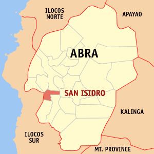
Map of San Isidro, Abra, Philippines
Geography
San Isidro is located at 17°28′N 120°36′E.
According to the Philippine Statistics Authority, the municipality has a land area of 48.07 square kilometres (18.56 sq mi) constituting 7000115000000099999♠1.15% of the 4,165.25-square-kilometre- (1,608.21 sq mi) total area of Abra.
Barangays
San Isidro is politically subdivided into 9 barangays.
Demographics
In the 2015 census, San Isidro had a population of 4,574. The population density was 95 inhabitants per square kilometre (250/sq mi).
In the 2016 electoral roll, it had 3,063 registered voters.