
Time zone PHT (UTC+8) Area 106.9 km² | District 5th district of Cebu ZIP code 6050 Mayor Aly Arquillano (BAKUD) | |
 | ||
Barangay Neighborhoods Monte Alegre, Esperanza, Santiago, Sonog | ||
San Francisco is a 3rd municipal income class municipality on Camotes Islands in the province of Cebu, Philippines. According to the 2015 census, it has a population of 55,180. In the 2016 electoral roll, it had 27,484 registered voters.
Contents
- Map of San Francisco Cebu Philippines
- Geography
- Barangays
- Demographics
- Tulang islet
- Protohistory
- 21st century
- Lake Danao
- Other sights
- Beaches
- References
Map of San Francisco, Cebu, Philippines
Geography
San Francisco consists primarily of Pacijan Island (also known as Pajican Island), as well as the tiny Tulang islet just north of Pacijan. Both islands are part of the Camotes Islands group in the Camotes Sea (that also includes Poro Island and Ponson Island). They are located east of the main island of Cebu, south and west of Leyte and north of Bohol.
Pacijan Island is about 14.75 kilometres (9.17 mi) long and 8.5 kilometres (5.3 mi) wide. A 1,400-metre (1,500 yd) causeway crosses the mangrove swamp to connect Pacijan and Poro Island. It was constructed during the Spanish era, to bridge the islands for easier trading and attending services in Poro church.
Barangays
San Francisco comprises 15 barangays:
Demographics
In the 2016 electoral roll, it had 27,484 registered voters, meaning that 50% of the population are aged 18 and over.
Tulang islet
Tulang island (known locally as Tulang Diot) is a five-minute boat ride from Tulang Dako on the main island of Pacijan. Both Tulang Diot and Tulang Dako are part of Esperanza barangay. The islet is almost entirely covered with coconut palms and measures about 1.6 by 0.6 kilometres (1.0 by 0.4 mi): the residential area is confined to a small triangle at the southern end. Total area about 40 ha (100 acres), of which only 3.5 ha (8.6 acres) (8.8%) is inhabited.
Protohistory
Carl Guthe, director of the University of Michigan Anthropological Museum, during his 1923-25 collecting trip and explorations of archaeological sites in the Philippines, conducted an archeological dig in a cave site on Tulang. Located on the southeastern coast of the island, the cave measures about 3.7 by 2.7 metres (12 by 9 feet). Guthe reported it to contain bone fragments and teeth of about 60 individuals. Associated grave goods included earthenware pottery, shell bracelets, bronze and iron artefacts (iron tang, bronze chisel, iron blade), glass and stone beads, hammerstone and pestle. Filed teeth were also recovered from this site.
21st century
Just before Typhoon Yolanda struck in November 2013, the mayor of San Francisco ordered the evacuation of all the residents (approximately 1,000) to the main island. This was credited with saving their lives as all houses on the island (about 500) were completely destroyed.
Lake Danao
1 Lake Danao is a freshwater lake located in the northern part of Pacijan Island, about 4.9 kilometres (3.0 mi) long and 1.8 kilometres (1.1 mi) wide, with an elevation of 5 metres (16 ft) above sea level. Its area of 680 ha (1,700 acres) makes it the largest lake not only in the province but also in the Visayas regions. It has two interior islands which can be reached by paddleboat or as part of the scenic lake cruise. An 18-kilometre (11 mi) hiking and cycling trail encircles the entire perimeter of the lake. Although classifies as "freshwater", that doesn't necessarily make it suitable for irrigation. A 2015 study determined which crops could be sustained.
Other sights
2 Tumibo Cave is a grotto in the Tumibo plateau in Sonog, which offers swimming in a crystal-clear underground pool.
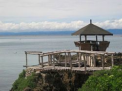
3 Arqui's Viewing Deck in the summit area of Monte Alegre offers outstanding picturesque views across Pacijan including Lake Danao and Tulang, as well as the islands of Cebu and Leyte beyond.
Beaches
4 Bakhaw Beach is located in Esperanza. Its sugary sand and clear waters make it safe for children.
5 Mangodlong Beach is one of the most visited beaches in the Camotes. It offers white sand and is located in the fishing village of Mangodlong in Himensulan. Across the beach is a coral islet.
6 Santiago Bay is located in the southwestern part of the island. The wide and deep white sand beach is situated directly in front of the town of Santiago. This beach is owned by the local government and is a favorite rendezvous for locals and visitors.