
Length 145 km Mouth elevation 0 | ||
 | ||
Main source Sierra Madre3,200 m (10,500 ft) River mouth Pacific Ocean0 m (0 ft) Discharge Average rate:8.7 m/s (310 cu ft/s) (Candelaria) | ||
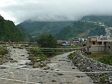
The Samalá is a river in southwestern Guatemala. Its sources are in the Sierra Madre range, in the departments of Totonicapán and Quetzaltenango. From there it flows down, past the towns San Cristóbal Totonicapán, Quetzaltenango, El Palmar and Zunil, through the coastal plains of Retalhuleu into the Pacific Ocean.
Map of Rio Samala, Guatemala
The Samalá river basin covers a territory of 1,510 square kilometres (580 sq mi) and has a population of around 400,000 people. Its proximity to the active Santa Maria and Santiaguito volcano complex, with its recurring lava and lahars flows, leads to a heightened risk of serious flooding.
References
Samalá River Wikipedia(Text) CC BY-SA