
Population 637 (2011) Civil parish Salterforth Dialling code 01282 | OS grid reference SD888454 Sovereign state United Kingdom UK parliament constituency Pendle | |
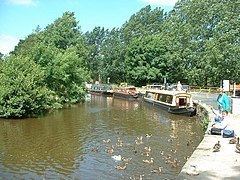 | ||
Salterforth is a village and civil parish within the Borough of Pendle in Lancashire, England. The population of the Civil Parish at the 2011 census was 637. It lies on the B6383 road that connects Barnoldswick to the A56 road at Kelbrook. The Leeds and Liverpool Canal cuts through the village and there are several narrowboat moorings at Salterforth. The canal footpath provides a picturesque walk to Barnoldswick or to Foulridge in the opposite direction.
Map of Salterforth, Barnoldswick, UK
Historically a part of the West Riding of Yorkshire, Salterforth used to be within Skipton Rural District until 1974. Some of the local area is referred to as West Craven alluding to Salterforth's cultural links to the Craven area of North Yorkshire.
Other local towns and villages are; Barnoldswick - 1 mile (1.6 km) north west, Kelbrook - 2 miles (3.2 km) east, Earby - 2 miles (3.2 km) north east, Thornton in Craven 3 miles (4.8 km) north east, Foulridge - 2 miles (3.2 km) south and Colne 3.5 miles (5.6 km) south.