
Type Meromictic lake Max. length 22 kilometres (14 mi) Surface area 44.77 km (17.29 sq mi) Surface elevation 9 m Mean depth 156 m Width 6 km | Basin countries Norway Max. width 6 kilometres (3.7 mi) Max depth 464 m Area 44.77 km² Length 22 km Shore length 105.6 km | |
 | ||
Location Fosnes and Nærøy, Nord-Trøndelag | ||
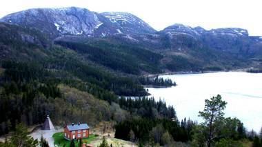
Salsvatnet is a lake in the municipalities of Fosnes and Nærøy in Nord-Trøndelag county, Norway. With its deepest depth of 464 metres (1,522 ft), it is Norway's and Europe's second-deepest lake, after Hornindalsvatnet. Alternate sources give the depth as either 464 metres (1,522 ft) or 482 metres (1,581 ft) at the deepest point. The lake sits very close to the ocean, about 9 metres (30 ft) above sea level at the surface and reaches to a depth of 455 metres (1,493 ft) below sea level. It is a very large lake with an area of 44.77 square kilometres (17.29 sq mi), a volume of 6.87 cubic kilometres (1.65 cu mi), and a shoreline that is 105.61 kilometres (65.62 mi) around.
Map of Salsvatn, Fosnes, Norway
Salsvatnet is a meromictic lake, meaning that the water is permanently stratified, often without oxygen in the lower depths (bottom water) due to density gradient and a lack of turnover. A meromictic lake often preserves records of the geologic past. The lower layer of the lake is highly saline and as a result denser than the higher levels of water. Other meromictic lakes in Norway with old seawater in the lower depths include Kilevann, Tronstadvann, Botnvatnet, Rørhopvatnet, and Rørholtfjorden.