
Population 50 Civil parish Salle Country England Area 8.21 km² Shire county Norfolk | OS grid reference TG109248 Region East Sovereign state United Kingdom Local time Wednesday 4:28 PM District Broadland | |
 | ||
Weather 16°C, Wind SW at 24 km/h, 71% Humidity | ||
Green man saint peter saint paul salle norfolk
Salle (/ˈsɔːl/ SAWL) is a village and civil parish in the English county of Norfolk. It is around 10 miles (16 km) north-west of Norwich in Broadland district. The village, which is pronounced Saul, gets its name from "Sallow Wood", Sallow referring to Willow in Norfolk.
Contents
- Green man saint peter saint paul salle norfolk
- Map of Salle UK
- St peter and st paul s church salle norfolk
- St Peter and St Pauls Church
- References
Map of Salle, UK
The civil parish has an area of 8.21 square kilometres (3.17 sq mi) and in 2001 had a population of 50 in 21 households.
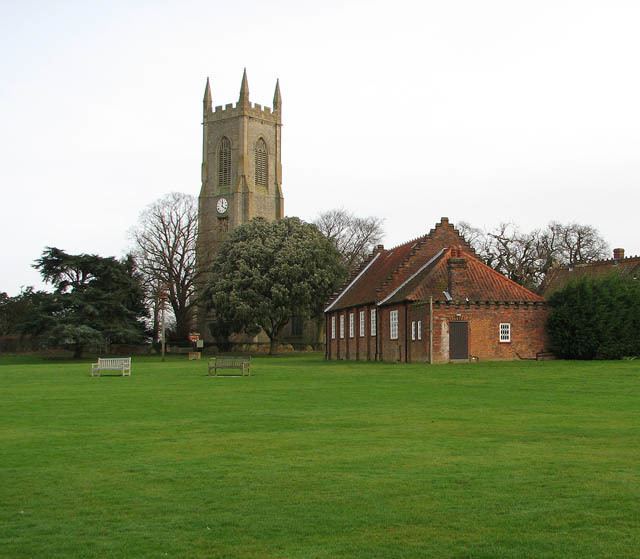
Salle is celebrated for its fine, huge late medieval church, which retains the lower part of its rood screen.
St peter and st paul s church salle norfolk
St Peter and St Paul's Church
The church, which dates from the first part of the 15th century, is an exceptionally complete Perpendicular building. It is huge for the size of the village - several lords of local manors, including the Boleyn family, vied with each other to fund the building of the church. There are many brasses, including to members of the Boleyn family.
The church retains some of its medieval stained glass in the east window and in the south transept south window. The font has a very tall Perpendicular canopy.
St Peter and St Paul's church was never collegiate, so it is peculiar that it has twenty six 15th century misericords. These are placed 13 on each side of the choir.