
Founded 1929 Lowest elevation 40 m (130 ft) Population 168,266 (1 Oct 2015) | Highest elevation 971 m (3,186 ft) Area 246.8 km² | |
 | ||
Website www.city.kyoto.lg.jp/sakyo/ Colleges and Universities Kyoto University, Kyoto Institute of Technology, Kyoto Seika University, Kyoto University of Art and, Kyoto Prefectural University Points of interest Ginkaku‑ji, Nanzen‑ji, Heian Shrine, Philosopher's Walk, National Museum of Modern A | ||
Sakyō-ku (左京区, Sakyō-ku) is one of the eleven wards in the city of Kyoto, in Kyoto Prefecture, Japan.
Contents
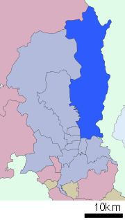
Map of Sakyo Ward, Kyoto, Kyoto Prefecture, Japan
History
The meaning of sakyō (左京) is "on the Emperor's left." When residing in the Kyoto Imperial Palace the emperor would sit facing south, thus the eastern direction would be to his left. Similarly, there is a ward to the west called Ukyō-ku (右京区), meaning "the ward on the Emperor's right." In old times, sakyō was referring to the eastern part of the capital, but the present Sakyō-ku is bounded to the west by the Kamo River, and is thus outside the historical capital.
It was created in 1929 when it was split off from Kamigyo-ku.
Geography
It is located in the north-east corner of Kyoto city. In the east it borders the city of Ōtsu in Shiga Prefecture. In the south Sanjō Street separates it from Higashiyama-ku and Yamashina-ku. In the north it borders the city of Nantan in Kyoto Prefecture and Takashima in Shiga Prefecture. In central Kyoto, the Kamo River flows on the western border of this ward.
Areas like Iwakura have been designated urbanization control areas, where large-scale exploitation and erection of tall buildings is restricted. Many rice fields remain in this area. The northern part of Sakyō-ku is mountainous and has a thriving forest industry.
The large streets Kawabata, Higashiōji and Shirakawa run from south to north. The train station Demachiyanagi is the terminal for both the Keihan railway with trains running south to Osaka, and the Eizan railway running north to Yase and Kurama.
Sights
Famous places located inside Sakyō-ku include Ginkaku-ji, Nanzen-ji, Kamo Shrine, Heian Shrine, and Hōnen-in.
In the northern parts are Kuramadera, Kifunejinja, Sanzen-in, the ruins of a house where Iwakura Tomomi was imprisoned, the Shugakuin Imperial Villa and Manshuin Temple, and the Kyoto International Conference Hall where the Kyoto Protocol was adopted.
Sakyō-ku also contains the Kyoto Botanical Garden and several of the mountains lit up during the yearly Gozan no Okuribi festival, including the main Daimonji-yama.
Education
In the southern part there are many residential areas and schools. For example, the main campus of Kyoto University is located here, as is Kyoto Institute of Technology and Kyoto Seika University.
The Kyoto Korean Junior High-High School, a North Korean school, is in the ward.