Country France Canton Sainte-Rose Population (2012) 6,777 Area 177.6 km² | INSEE/Postal code 97419 /97439 Local time Wednesday 7:18 AM | |
 | ||
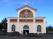
Weather 26°C, Wind N at 6 km/h, 79% Humidity Points of interest Piton de la Fournaise, Anse des Cascades, Pas de Bellecombe, Notre Dame des Laves, Cratère Dolomieu | ||
Sainte-Rose is a commune on the east coast of the French island and department of Réunion.
Contents
Map of Sainte Rose, Reunion
Geography
The commune is bordered by the communes of La Plaine-des-Palmistes, Saint-Benoît, Saint-Joseph, Saint-Philippe and Tampon; and by the Rivière de l'Est to the nord. Sainte-Rose is home to the first wind farm on the island, built in 2004.
The "Pointe des Cascades", in the commune, is the easternmost part of the island and also the easternmost part of France and of the European Union.
History
The village of Piton Sainte-Rose was partially destroyed by a lava flow in April 1977.
References
Sainte-Rose, Réunion Wikipedia(Text) CC BY-SA
