
Country Canada Constituted December 30, 1976 Postal code(s) J0W 1V0 Area 344.7 km² Local time Tuesday 10:18 PM Area code 819 | Settled 1910s Time zone EST (UTC−5) Highways Route 309 Population 619 (2011) Province Québec | |
 | ||
Weather 1°C, Wind N at 5 km/h, 76% Humidity RCMs Laurentides, Antoine-Labelle Regional County Municipality | ||
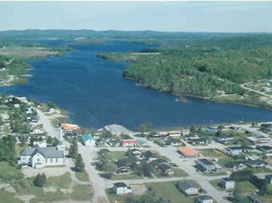
Sainte-Anne-du-Lac is a municipality and village in the Laurentides region of Quebec, Canada, part of the Antoine-Labelle Regional County Municipality.
Contents
Map of Sainte-Anne-du-Lac, QC, Canada
Sainte-Anne-du-Lac is the northern-most place in the Laurentides region, about 46 kilometres (29 mi) from Mont-Laurier. The village itself is located at the northern terminus of Quebec Route 309, on the south shore of Lake Tapani.
Demographics
Population trend:
Private dwellings occupied by usual residents: 290 (total dwellings: 426)
Mother tongue:
References
Sainte-Anne-du-Lac, Laurentides, Quebec Wikipedia(Text) CC BY-SA