
Country Canada RCM Charlevoix-Est Time zone EST (UTC−5) Area 412.3 km² | Region Capitale-Nationale Constituted April 25, 2001 Postal code(s) G0T 1X0 Province Québec | |
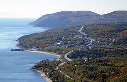 | ||
Saint-Siméon is a municipality in the Charlevoix-Est Regional County Municipality of Quebec, Canada. Founded in 1869, it was named after Saint Simeon of Jerusalem.
Contents
Map of Saint-Sim%C3%A9on, QC, Canada
Its population centres include Saint-Siméon, Baie-des-Rochers, Port-au-Persil, and Port-aux-Quilles, all located along Route 138.
History
The municipality was first formed as a parish municipality in 1869 when it separated from Saint-Fidèle-de-Mont-Murray (now part of La Malbaie). Its post office opened in 1882. In 1911, the main village itself separated from the parish municipality and was incorporated as the Village Municipality of Saint-Siméon. In 2001, both municipal entities were rejoined as the new Municipality of Saint-Siméon.
Population
Population trend:
Private dwellings occupied by usual residents: 551 (total dwellings: 702)
Language
Mother tongue: