
Time zone CET (UTC+1) Area 29.58 km² Population 284 (1999) | INSEE/Postal code 24464 /24270 Local time Wednesday 12:15 AM | |
 | ||
Weather 11°C, Wind NE at 8 km/h, 73% Humidity | ||
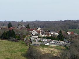
Saint-Mesmin is a commune in the Dordogne department in Nouvelle-Aquitaine in southwestern France.
Contents
Map of 24270 Saint-Mesmin, France
Geography
The commune is located in the north-east corner of the Dordogne department, on a hill above the river Auvézère. The village is located 42 km (26 mi) north-east of Périgueux. The area consists of forests and farmland.
History
From the creation of the departments in 1790 Saint-Mesmin was first included in the Corrèze department. Three years later in 1793 it joined the Dordogne department.
Population
The largest population that the census recorded was 1,168 in 1886. Since World War I, the population has gradually been declining.
Sights
References
Saint-Mesmin, Dordogne Wikipedia(Text) CC BY-SA