Arrondissement Neufchâteau Postal code 6870 | Postal codes 6870 Local time Tuesday 9:10 PM | |
 | ||
Weather 11°C, Wind SW at 11 km/h, 68% Humidity Points of interest Basilique des Saints‑Pierre‑et‑Paul, Fourneau Saint‑Michel, Parc à Gibier de Saint‑Hubert, Mirwart Castle, Musée Redouté | ||
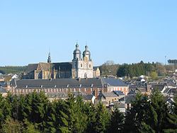
Saint-Hubert ([sɛ̃.t‿y.bɛʁ]) is a Walloon municipality of Belgium located in the province of Luxembourg. On 1 January 2007 the municipality, which covers 111.16 km², had 5,737 inhabitants, giving a population density of 51.6 inhabitants per square kilometre.
Map of 6870 Saint-Hubert, Belgium
The municipality consists of the following sub-municipalities: Saint-Hubert proper, Arville, Awenne, Hatrival, Mirwart, and Vesqueville. Other population centers include: Lorcy and Poix-Saint-Hubert.
The town is named in commemoration of Saint Hubert, whose body was moved in 825 to the Benedictine Abbey of Andage, thereafter called Abbey of Saint-Hubert.
References
Saint-Hubert, Belgium Wikipedia(Text) CC BY-SA
