
Area 135 km² Local time Tuesday 1:20 PM | Phone number 0175-38-2111 Population 2,149 (28 Feb 2017) | |
 | ||
Weather 7°C, Wind W at 29 km/h, 75% Humidity | ||
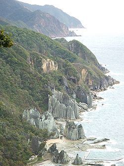
Sai (佐井村, Sai-mura) is a village located in Shimokita District of northeastern Aomori Prefecture in the northern Tōhoku region of northern Japan. As of 28 February 2017, the village had an estimated population of 2,149 and a population density of 15.9 persons per km2 in 978 households. Its total area was 135.04 square kilometres (52.14 sq mi). In 2106, Sai was selected as one of The Most Beautiful Villages in Japan.
Contents
- Map of Sai Shimokita District Aomori Prefecture Japan
- Geography
- Neighbouring municipalities
- Demographics
- History
- Economy
- Education
- Railway
- Highway
- Local attractions
- Local events
- Noted people from Sai
- References
Map of Sai, Shimokita District, Aomori Prefecture, Japan
Geography
Sai occupies the western coastline of Shimokita Peninsula, facing the inlet to Mutsu Bay from the Tsugaru Strait. The village has a cold oceanic climate characterized by cool short summers and long cold winters with heavy snowfall and strong winds (Köppen climate classification Cfb). The average annual temperature in Sai is 8.9 °C. The average annual rainfall is 1258 mm with September as the wettest month.The temperatures are highest on average in August, at around 21.8 °C, and lowest in January, at around -2.7 °C. Much of the village is within the limits of the Shimokita Hantō Quasi-National Park. The mountainous area is home to many indigenous plant and animal species. Wildlife includes Japanese macaque monkeys, kamoshika, tanuki and Asian black bears. Approximately 90% of the village area is forested, of which 90% is national forest.
Neighbouring municipalities
Demographics
Per Japanese census data, the population of Sai has declined over the past 40 years.
History
The area around Sai was inhabited by the Emishi people until the historical period. During the Edo period, it was controlled by the Nambu clan of Morioka Domain and prospered due to its timber industry and as a ferry terminal to Ezo. During the post-Meiji restoration cadastral reform of 1 April 1889, Sai Village was proclaimed from the merger of Sai hamlet with neighboring Chōgō hamlet.
Economy
The economy of Sai is heavily dependent on forestry and commercial fishing. Approximately 90% of the village area is covered by mountains and forest, of which approximately 90% is national forest. Some of the locally caught seafood include sea urchin roe, sea pineapple, sea cucumber, scallops, abalone, konbu and squid. Seasonal tourism is also an important contributor to the local economy.
Education
Sai has one public elementary school, one public middle school and two combined public elementary/middle schools operated by the village government. The village does not have a high school.