
Country Japan - Tree Cherry Area 139 km² Local time Tuesday 9:28 AM | Region Tōhoku - Flower Azalea Population 41,174 (Oct 2015) Prefecture Yamagata Prefecture | |
 | ||
Time zone Japan Standard Time (UTC+9) - Plant Sagae Gibōshi (Hosta ‘Sagae’) Weather 4°C, Wind W at 11 km/h, 70% Humidity Points of interest Mogamigawafurusato Park, Jionji, Sagaehachimangu, Mt Hayama | ||
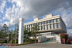
Sagae (寒河江市, Sagae-shi) is a city located in Yamagata Prefecture, in the Tohoku region of northern Japan.
Contents
- Map of Sagae Yamagata Prefecture Japan
- Geography
- Neighboring municipalities
- Climate
- History
- Economy
- Railway
- Highway
- Local attractions
- Sister cities
- Noted people from Sagae
- References
Map of Sagae, Yamagata Prefecture, Japan
As of October 2015, the city had an estimated population of 41,174 and a population density of 296 persons per km². The total area was 139.03 square kilometres (54 sq mi).
Geography
Sagae is located in the Yamagata Basin in the geographic center of Yamagata Prefecture. The Asahi Mountains and Dewa Mountains form its western border, and the Mogami River forms the eastern border of the city.
Neighboring municipalities
Climate
Sagae has a Humid continental climate (Köppen climate classification Dfa) with large seasonal temperature differences, with warm to hot (and often humid) summers and cold (sometimes severely cold) winters. Precipitation is significant throughout the year, but is heaviest from August to October.
History
The area of present-day Sagae was part of ancient Dewa Province, and has been settled since prehistoric times, with numerous archaeological findings from the Japanese Paleolithic through the Kofun periods. In the late Heian through Kamakura periods, it was a shōen under the control of the Ōe clan. The Ōe were destroyed by the Mogami clan in the Sengoku period, who were in turn destroyed by the Tokugawa shogunate in the early Edo period. The territory was administered as tenryō under direct control of the shogunate until the Meiji Restoration, and was briefly a battleground in the Boshin War. After the start of the Meiji period, the area became part of Nishimurayama District, Yamagata Prefecture. The modern village of Sagae was established on April 1, 1889, and was raised to town status on January 7, 1893. It became a city on August 1, 1954.
Economy
The economy of Sagae is primarily based on agriculture.