
OS grid reference TQ271114 Country England Post town POYNINGS Shire county West Sussex Dialling code 01273 UK parliament constituency Arundel and South Downs | Region South East Sovereign state United Kingdom Postcode district BN45 District Mid Sussex Civil parish Newtimber | |
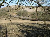 | ||
Saddlescombe is a hamlet in the Newtimber Parish of Mid Sussex district of West Sussex, England. It lies on the road from Poynings to Brighton, 5.4 miles (8.7 km) northwest of Brighton.
Map of Saddlescombe, Brighton, UK
Saddlescombe Farm is a busy little hamlet sitting at the base of the Downs which is owned by the National Trust along with the surrounding countryside. Listed as a working farm since the Domesday Book and having belonged to the Knights Templar for around 100 years - there are plenty of historic buildings to explore.
The hamlet consists of several threshing barns, large storage barns, a variety of houses, forge, cattle yard and dairy, duck pond, donkey wheel, pig sties, chicken coops and old stables! There is also a very popular organic cafe in one of the courtyards just off the South Downs Way from where you can view the farm and the free range chickens.
The farm is open several times a year for open days with group tours and events being organised by the National Trust throughout the year. There is no public parking available within the hamlet, but a free gravel car park can be found on the other side of the road which also leads up to the Devil's Dyke viewpoint - and from where you can catch the 77 bus to and from Brighton Station.
Most of the countryside around Saddlescombe is Open Access meaning you can wander freely over the chalkland.