
 | ||
Saddle landform top 5 facts
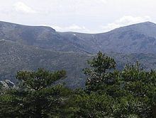
The saddle between two hills (or mountains) is the region surrounding the highest point of the lowest point on the line (tracing the drainage divide, the Col) connecting the peaks. When, and if, the saddle is navigable, even if only on foot, the saddle of a (optimal) pass between the two massifs, is the area generally found around the lowest route on which one could pass between the two summits, which includes that point which is a mathematically when graphed a relative high along one axis, and a relative low in the athwart axis, simultaneously; that point being by definition the Col of the saddle.
Contents
- Saddle landform top 5 facts
- Mathematical Saddles
- Structural geology
- Road beds Cols and placements
- References
Mathematical Saddles
In mathematics, a saddle point is a point in the domain of a function where the slopes (derivitives) of orthoganal function components defining the surface become zero (a stationary point) but are not a local extremum on both axes. The saddle point will always occur at a relative minima along one axial direction (between peaks) and where the crossing axis is a relative maxima.
The name derives from the fact that the prototypical example in two dimensions is a surface that curves up in one direction, and curves down in a different direction, resembling a riding saddle or a mountain pass between two peaks forming a landform saddle. In terms of contour lines, a saddle point in two dimensions gives rise to a contour graph or trace that appears to intersect itself—such conceptually might form a 'figure eight' around both peaks; assuming the contour graph is at the very 'specific altitude' of the saddle point in three dimensions.
Structural geology
In structural geology a saddle is a depression located along the axial trend of an anticline. This is not to be confused with a col which is typically a geomorphologic feature seen in landforms.
In plain language, a saddle is the lowest area between two highlands (prominences or peaks) but has two wings which span the divide (the line between the two prominences) by crossing the divide at an angle, so is concurrently the local highpoint of the land surface which falls off in the down direction. That is, the drainage divide is a ridge along the high point of the saddle, as well as between the two peaks so defines the major reference axis. A saddle can vary from a sharp narrow gap to a broad comfortable sway-backed shallow valley so long as it is both the high point in the sloping faces descending to lower elevations and the low area between the two (or three or four.) flanking summits. Concurrently, along a different axis, it is the low point between two peaks, so is the likely 'optimal' high point in a pass if the saddle is traversed by a track, road or railway.
Road beds, Cols and placements
Note, a road bed through a pass need not be through a Col (so will then have to be along a traverse face of one peak or the other, and the road bed will be cutting across the divide at nearly ninety degrees), but by not encompassing the Col, mathematically requires the road bed be above the altitude of the Col.