
Basin size 197.7 km (76.3 sq mi) Mouth Mediterranean Sea Mouth elevation 0 | Length 49 km Country Spain | |
 | ||
Main source Barranc del Salt, Ports de Beseit
1,200 m (3,900 ft) River mouth Sòl de Riu, Mediterranean Sea
0 m (0 ft) | ||
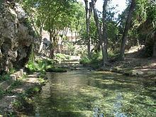
The Sénia River (Catalan: Riu de la Sénia, Spanish: Río Cenia) is a river in the provinces of Castellón and Tarragona, Spain It begins its course at 1,200 metres (3,900 ft) in the Barranc del Salt, Ports de Beseit limestone massif near La Pobla de Benifassà.
Contents
Map of Riu de la S%C3%A9nia, Spain
The Sénia flows from west to east marking the historical limits between Catalonia (Montsià) and the Valencian Community (Baix Maestrat). It ends its course in the Mediterranean Sea at Sòl de Riu., between Vinaròs and Alcanar municipalities. Its flow is highly irregular. Some years its riverbed remains dry during the whole stretch of its lower course.
The Ulldecona Dam is a dam built across three tributaries of the Sénia river in the Tinença de Benifassà area. With a surface of 116 hectares (290 acres) and a capacity of 11 cubic hectometres (8,900 acre·ft), its reservoir is very important for the irrigation of fields of the region.