
Population 461 Civil parish Rushton | OS grid reference SP8482 Sovereign state United Kingdom Local time Saturday 1:06 AM Dialling code 01536 | |
 | ||
Weather 3°C, Wind NE at 13 km/h, 92% Humidity | ||
Rushton is a small hamlet and civil parish in Northamptonshire. It is about 2 miles (3.2 km) north-east of Rothwell and 3 miles (4.8 km) north-west of Kettering. The parish covers 3,200 acres (1,300 ha) and is situated on both sides of the River Ise. It contains the sites of three deserted settlements, details of which are set out below.
Contents
Map of Rushton, Kettering, UK
At the time of the 2001 census, the parish's population was 452 people, increasing slightly to 461 at the 2011 Census. The village has a primary school and a pub opposite the village cricket pitch.
Buildings
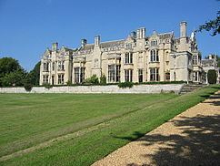
The village is home to Rushton Triangular Lodge which is in the former grounds of Rushton Hall which is 0.5 miles (0.80 km) west of the village; the hall is currently an hotel.
All Saints Church is of Norman origin but mostly 14th-century with 19th-century restorations in 1853 and 1869 by Edmund Francis Law. There is a monument to Sir Thomas Tresham (died 8 March 1559) of Rushton Hall.
Other notable buildings in the village include a Manor House east of the church, Manor Farm House (17th-century) and the Georgian Old Rectory.
Deserted settlements
The location, history and remaining physical evidence of three deserted settlements within the parish have been systematically documented.
Barford - This lay near Barford Lodge and is listed in the Domesday Book with seven recorded inhabitants. In 1516, George Boyvil enclosed 86 acres of arable land at Barford and it was reported that "almost the whole village" was destroyed. The chapel that formerly served this village was no longer in existence in the early 18th century.
Glendon - This was immediately east of Glendon Hall, with a recorded population of fourteen in the Domesday Book. In 1327, there were ten tenants on the manor. In 1514, Robert Malory enclosed 494 acres of arable land as well as pasture. At that time, nine out of the twelve houses were destroyed.
Rushton St Peter - The site of this settlement is in the area of Rushton Hall. It was listed along with Rushton All Saints in the Domesday Book with a combined recorded population of 45. In the 1524 Subsidy Returns, only ten people paid tax at St Peter's parish, compared to 28 in All Saints. In the early 18th century, it was recorded that the only buildings in St Peter's parish were the hall, the church and four or five shepherd's lodges. The two Rushton parishes were united in 1780 and a faculty was granted in 1799 for the demolition of St Peter's church.