
Population 60 (estimated, 2016) Country England Post town Lowestoft Shire county Suffolk District Waveney | Region East Sovereign state United Kingdom Postcode district NR33 Local time Saturday 12:56 AM Dialling code 01502 | |
 | ||
Weather 6°C, Wind NE at 16 km/h, 84% Humidity | ||
Rushmere is a village and civil parish in the Waveney district of the English county of Suffolk. The village is around 5 miles (8.0 km) south-west of Lowestoft and 5 1⁄2 miles (8.9 km) south-east of Beccles. Neighbouring parishes include Carlton Colville, Gisleham, Henstead and Hulver Street, Kessingland and Mutford. The Hundred River forms the southern boundary of the parish.
Contents
Map of Rushmere, Lowestoft, UK
Settlement within the parish is dispersed without a village centre. The population was estimated at 60 in 2016. The majority of the land in the parish is agricultural with the name meaning a rushy enclosure or lake.
History
The village was recorded in the Domesday Book with around 18 households as part of the holdings of King William. The population varied between around 100 and 150 between 1800 and 1950 before declining in the later 20th century. In 1846 the manor formed part of the land owned by Samuel Morton Peto. Rushmere Hall, which dates to the 16th century, is a Grade II* listed farmhouse.
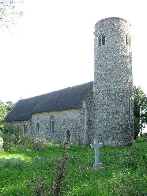
The parish church is a round-tower church which dates to the Norman period and is a Grade I listed building. The church is dedicated to St. Michael and All Angels and is situated to the north of the parish, close to the parish boundary with Mutford. The majority of the building is medieval and the roof is thatched. The building was derelict in the 1930s but was restored by the local community and reopened in 2010.