
Length 197 km | Source elevation 18 m | |
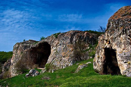 | ||
River mouth near Rousse, Bulgaria18 m (59 ft) Similar Rock‑hewn Churches of Ivanovo, Basarbovo Monastery, Cherven, Yantra, Orlova Chuka | ||
The Rusenski Lom (Bulgarian: Русенски Лом) is a river in northeastern Bulgaria, the last major right tributary of the Danube. It is formed by the rivers Beli Lom and Cherni Lom, the former taking its source south of Razgrad and the latter southeast of Popovo.
Map of r. Rusenski Lom, Bulgaria
The source of the Beli Lom at 43°24′N 26°40′E and 360 metres (1,180 ft) above sea level is provisionally accepted as the point where the Rusenski Lom starts. Before they merge, the two rivers have a length of 130 kilometres (81 mi) for the Cherni Lom and 140 kilometres (87 mi) for the Beli Lom and a drainage basin of 1,549 square kilometres (598 sq mi) and 1,276 square kilometres (493 sq mi) respectively. Both rivers primarily run northwestwards, with the Beli Lom going west at Senovo and the Cherni Lom flowing northeast after Shirokovo, as the two rivers get closer to merge north of Ivanovo. The Rusenski Lom empties into the Danube at the city of Rousse, which gives the river its name. The total length from the source of the Beli Lom is 196.9 kilometres (122.3 mi). The coordinates of the mouth are 43°50′N 25°56′E, 18 metres (59 ft) above sea level.
The Rusenski Lom flows through Rusenski Lom Nature Park.