
Country Germany Basin size 4,485 km (1,732 sq mi) Length 217 km Mouth Rhine | River mouth Rhine Basin area 4,485 km² Source Sauerland | |
 | ||
Main source Sauerland
674 m (2,211 ft) Discharge Average rate:
79 m/s (2,800 cu ft/s) Cities Mülheim, Essen, Bochum, Duisburg, Dortmund Bridges Schwimmbrücke Dahlhausen, Ruhrtalbrücke Mülheim Similar Rhine, Hengsteysee, Zollverein Coal Mine Industrial, Volme, Landschaftspark Duisburg‑Nord | ||
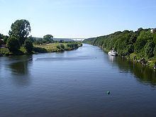
The Ruhr is a river in western Germany (North Rhine-Westphalia), a right tributary (east-side) of the Rhine.
Contents
Map of Ruhr, Germany
Description and historyEdit
The source of the Ruhr is near the town of Winterberg in the mountainous Sauerland region, at an elevation of approximately 2,200 feet (670 m). It flows into the lower Rhine at an elevation of only 56 feet (17 m) in the municipal area of Duisburg. Its total length is 218 km (135 mi), its average discharge is 79 m³/s (cubic metres per second) at Mülheim near its mouth. Thus, its discharge is, for example, comparable to that of the River Ems in Northern Germany or the River Thames in the United Kingdom.
The Ruhr first passes the towns of Meschede, Arnsberg, Wickede, Fröndenberg, Holzwickede, Iserlohn and Schwerte. Then the river marks the southern limit of the Ruhr area, passing Hagen, Dortmund, Herdecke, Wetter, Witten, Bochum, Hattingen, Essen, Mülheim and Duisburg.
The Ruhr area was Germany's primary industrial area during the early- to mid-20th century. Most factories were located there. The occupation of the Ruhr from 1923-24 by French forces, due to the Weimar Republic's failure to continue paying reparations from World War I, provoked passive resistance, which saw production in the factories grind to a halt. As a result, the German hyperinflation crisis grew even worse.
During World War II, two of the dams on the Ruhr, the Möhne Dam and the Sorpe Dam were targets for Operation Chastise, in which special "bouncing bombs" were developed to take out the dams and flood the valley, with the hope of seriously affecting the German industries there. The story was told in a 1951 book and the popular 1955 film made from it, The Dam Busters.
LakesEdit
There are five Ruhr reservoirs on the river, often used for leisure activities.