
Length 25 km Mouth Sill Bridges Stefansbrücke | Source Stubaital Country Austria | |
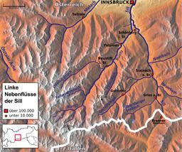 | ||
- location glacier area are of the Stubaital | ||
The Ruetz River flows from the glacier area of the valley to the Wipptal in north-east direction. Near the famous "Europe bridge", it merges with the Sill River after a route length of appr. 25 km. The river crosses straight the village of Fulpmes providing a nearby power station of the Austrian Railway Services with electricity.
Map of Ruetz, Austria
As a typical rapid-river the Ruetz is pretty dangerous and full of rapids. Before several defence structures had been constructed, it was quite feared due to floods. However, the water quality is very good and several communities in the Stubai Valley use the river as drinking water resource.
References
Ruetz Wikipedia(Text) CC BY-SA