
Country New Zealand | Region West Coast Local time Friday 3:02 PM | |
 | ||
Weather 16°C, Wind NE at 6 km/h, 68% Humidity | ||
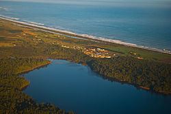
Ruatapu is a small town in the Westland District in the West Coast region of the South Island of New Zealand. The town's name stems from Ruatapu, a figure in Māori mythology. The town is located on a narrow strip of land between the Tasman Sea and Lake Mahinapua, a shallow lake that was originally a coastal lagoon. State Highway 6 runs through Ruatapu, connecting it to the nearby towns of Hokitika and Ross. The town's economy is based upon agriculture, as well as a large sawmill, operated by Westco Lagan, which mills Radiata Pine for further processing in Christchurch.
Contents
Map of Ruatapu 7883, New Zealand
History
On 9 November 1906, the Midland railway line, running from Greymouth to Hokitika, extended a branch line to Ruatapu. Ruatapu acted as the terminus of the railway until 1 April 1909, when it was opened to Ross, and became known as the Ross Branch. Passenger services ceased on 9 October 1972 and the line closed to all traffic on 24 November 1980. Some of the track bed near Ruatapu can now be driven. A large storm in October 1915 ripped the roof off the sawmill (at the time operated by Butler Bros.), demolished a hut, and shifted another house from its foundations.